Saint-Androny geodata
Saint-Androny (Nouvelle-Aquitaine) is a populated place; located in France in Europe/Paris (GMT+2) time zone. With population of 616 people, there are 13048 cities with bigger population in this country. Compared to other cities in France, 77.5% of cities are located further ↑North; 85% of cities are located further →East and 98.2% of cities have higher elevation than Saint-Androny. Note1
Administrative division(s):
- Level 1: Nouvelle-Aquitaine
- Level 2: Gironde
- Level 3: Arrondissement de Blaye
- Level 4: Saint-Androny


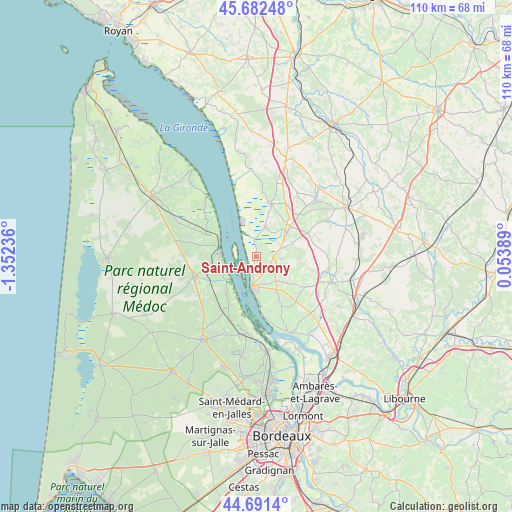
Saint-Androny GPS coordinates[2]
45° 11' 20.76" North, 0° 38' 57.264" West
| Map corner | latitude | longitude |
|---|---|---|
| Upper-left | 45.68248°, | -1.35236° |
| Center: | 45.1891°, | -0.64924° |
| Lower-right: | 44.6914°, | 0.05389° |
| Map W x H: | 110.2×110.2 km | = 68.5×68.5mi |
| max Lat: | 51.07786° ⇑77.5% North |
| Saint-Androny: | 45.1891° |
| min Lat: | ⇓22.5% South 41.3874° |
| min Long | Saint-Androny | max Long |
| -5.08615° | -0.64924° | 9.52242° |
| W 15%⇐ | ⇒85% E |
Elevation
Elevation of Saint-Androny is 8 m = 26 ft, and this is 185.7 m = 609 ft below average elevation for this country.
| Max E: |
2333 m = 7654 ft | 98.2% |
| Avg. | 193.7 m = 635 ft | |
| Saint-Androny | 8 m = 26 ft | |
Min E: |
-1 m = -3 ft | 1.8% |
See also: France elevation on elevation.city.
Geographical zone
Saint-Androny is located in North temperate zone (between Tropic of Cancer and the Arctic Circle). Distance of this North polar circle is 2376.6 km =1476.8 mi to North.| Distance of | km | miles | from Saint-Androny |
|---|---|---|---|
| North Pole | 4982.5 | 3096 | to North |
| Arctic Circle | 2376.6 | 1476.8 | to North |
| Tropic Cancer | 2418.6 | 1502.8 | to South |
| Equator | 5024.6 | 3122.1 | to South |


Nearby cities:
15 places around Saint-Androny: (largest is in red/bold)
• Anglade
2.5 km =1.6 mi,  27°
27°
• Blaye
6.9 km =4.3 mi,  188°
188°
• Braud-et-Saint-Louis
6.7 km =4.2 mi,  16°
16°
• Cars
7.1 km =4.4 mi,  160°
160°
• Cartelègue
5.3 km =3.3 mi,  94°
94°
• Eyrans
2.5 km =1.6 mi, 92°
• Générac
8 km =5 mi,  96°
96°
• Pauillac
7.8 km =4.8 mi,  275°
275°
• Plassac
9.5 km =5.9 mi,  178°
178°
• Saint-Girons-d’Aiguevives
10 km =6.2 mi,  123°
123°
• Saint-Julien-Beychevelle
7.7 km =4.8 mi,  251°
251°
• Saint-Martin-Lacaussade
4.8 km =3 mi,  174°
174°
• Saint-Paul
5.8 km =3.6 mi,  142°
142°
• Saint-Seurin-de-Cursac
3.8 km =2.4 mi,  146°
146°
• Étauliers
7.3 km =4.5 mi,  55°
55°
Sources, notices
• [Note1] Compared only with cities in France existing in our database
• [Src1] Map data: © OpenStreetMap contributors (CC-BY-SA)
• [Src2] Other city data from geonames.org with taken over terms of usage.
• [Src3] Geographical zone / Annual Mean Temperature by Robert A. Rohde @ Wikipedia
