Saint-André-le-Puy geodata
Saint-André-le-Puy (Auvergne-Rhône-Alpes) is a populated place; located in France in Europe/Paris (GMT+2) time zone. With population of 1,217 people, there are 7448 cities with bigger population in this country. Compared to other cities in France, 71.8% of cities are located further ↑North; 70.2% of cities are located further ←West and 86.5% of cities have lower elevation than Saint-André-le-Puy. Note1
Administrative division(s):
- Level 1: Auvergne-Rhône-Alpes
- Level 2: Département de la Loire
- Level 3: Arrondissement de Montbrison
- Level 4: Saint-André-le-Puy


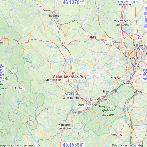
Saint-André-le-Puy GPS coordinates[2]
45° 38' 51.468" North, 4° 15' 31.932" East
| Map corner | latitude | longitude |
|---|---|---|
| Upper-left | 46.13701°, | 3.55575° |
| Center: | 45.64763°, | 4.25887° |
| Lower-right: | 45.15394°, | 4.962° |
| Map W x H: | 109.3×109.3 km | = 67.9×67.9mi |
| max Lat: | 51.07786° ⇑71.8% North |
| Saint-André-le-Puy: | 45.64763° |
| min Lat: | ⇓28.2% South 41.3874° |
| min Long | Saint-André-le | max Long |
| -5.08615° | 4.25887° | 9.52242° |
| W 70.2%⇐ | ⇒29.8% E |
Elevation
Elevation of Saint-André-le-Puy is 367 m = 1204 ft, and this is 173.3 m = 569 ft above average elevation for this country.
| Max E: |
2333 m = 7654 ft | 13.5% |
| Saint-André-le-Puy | 367 m 1204 ft | |
| Avg. | 193.7 m = 635 ft | |
Min E: |
-1 m = -3 ft | 86.5% |
See also: France elevation on elevation.city.
Geographical zone
Saint-André-le-Puy is located in North temperate zone (between Tropic of Cancer and the Arctic Circle). Distance of this North polar circle is 2325.6 km =1445.1 mi to North.| Distance of | km | miles | from Saint-André-le-Puy |
|---|---|---|---|
| North Pole | 4931.5 | 3064.3 | to North |
| Arctic Circle | 2325.6 | 1445.1 | to North |
| Tropic Cancer | 2469.6 | 1534.5 | to South |
| Equator | 5075.5 | 3153.8 | to South |


Nearby cities:
15 places around Saint-André-le-Puy: (largest is in red/bold)
• Bellegarde-en-Forez
3 km =1.9 mi,  96°
96°
• Boisset-lès-Montrond
4.2 km =2.6 mi,  237°
237°
• Chambœuf
8.4 km =5.2 mi,  147°
147°
• Craintilleux
7.6 km =4.7 mi,  197°
197°
• Cuzieu
4.4 km =2.7 mi,  181°
181°
• Feurs
9.8 km =6.1 mi,  345°
345°
• Maringes
7.3 km =4.5 mi,  77°
77°
• Montrond-les-Bains
1.7 km =1.1 mi,  255°
255°
• Saint-Cyr-les-Vignes
3.8 km =2.4 mi,  49°
49°
• Saint-Galmier
6.9 km =4.3 mi,  143°
143°
• Saint-Laurent-la-Conche
5.6 km =3.5 mi,  317°
317°
• Saint-Médard-en-Forez
9.5 km =5.9 mi,  123°
123°
• Valeille
7.6 km =4.7 mi,  27°
27°
• Veauche
9.7 km =6 mi,  164°
164°
• Veauchette
9.5 km =5.9 mi, 178°
Sources, notices
• [Note1] Compared only with cities in France existing in our database
• [Src1] Map data: © OpenStreetMap contributors (CC-BY-SA)
• [Src2] Other city data from geonames.org with taken over terms of usage.
• [Src3] Geographical zone / Annual Mean Temperature by Robert A. Rohde @ Wikipedia
