Feurs geodata
Feurs (Auvergne-Rhône-Alpes) is a populated place; located in France in Europe/Paris (GMT+2) time zone. With population of 7,901 people, there are 1227 cities with bigger population in this country. Compared to other cities in France, 70.3% of cities are located further ↑North; 70% of cities are located further ←West and 85.3% of cities have lower elevation than Feurs. Note1
Administrative division(s):
- Level 1: Auvergne-Rhône-Alpes
- Level 2: Département de la Loire
- Level 3: Arrondissement de Montbrison
- Level 4: Feurs


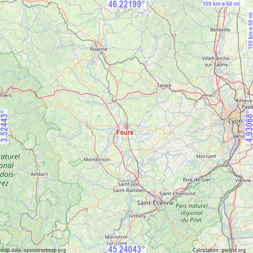
Feurs GPS coordinates[2]
45° 44' 0.132" North, 4° 13' 39.18" East
| Map corner | latitude | longitude |
|---|---|---|
| Upper-left | 46.22199°, | 3.52443° |
| Center: | 45.73337°, | 4.22755° |
| Lower-right: | 45.24043°, | 4.93068° |
| Map W x H: | 109.1×109.1 km | = 67.8×67.8mi |
| max Lat: | 51.07786° ⇑70.3% North |
| Feurs: | 45.73337° |
| min Lat: | ⇓29.7% South 41.3874° |
| min Long | Feurs | max Long |
| -5.08615° | 4.22755° | 9.52242° |
| W 70%⇐ | ⇒30% E |
Elevation
Elevation of Feurs is 350 m = 1148 ft, and this is 156.3 m = 513 ft above average elevation for this country.
| Max E: |
2333 m = 7654 ft | 14.7% |
| Feurs | 350 m 1148 ft | |
| Avg. | 193.7 m = 635 ft | |
Min E: |
-1 m = -3 ft | 85.3% |
See also: France elevation on elevation.city.
Geographical zone
Feurs is located in North temperate zone (between Tropic of Cancer and the Arctic Circle). Distance of this North polar circle is 2316.1 km =1439.2 mi to North.| Distance of | km | miles | from Feurs |
|---|---|---|---|
| North Pole | 4922 | 3058.4 | to North |
| Arctic Circle | 2316.1 | 1439.2 | to North |
| Tropic Cancer | 2479.2 | 1540.5 | to South |
| Equator | 5085.1 | 3159.7 | to South |


Nearby cities:
15 places around Feurs: (largest is in red/bold)
• Balbigny
10 km =6.2 mi,  343°
343°
• Civens
5.5 km =3.4 mi,  20°
20°
• Cottance
8.7 km =5.4 mi,  40°
40°
• Montrond-les-Bains
10 km =6.2 mi,  175°
175°
• Nervieux
9.8 km =6.1 mi,  322°
322°
• Poncins
4.6 km =2.9 mi,  258°
258°
• Pouilly-lès-Feurs
7.2 km =4.5 mi,  3°
3°
• Rozier-en-Donzy
8.4 km =5.2 mi,  27°
27°
• Saint-André-le-Puy
9.8 km =6.1 mi,  165°
165°
• Saint-Barthélemy-Lestra
8.9 km =5.5 mi,  100°
100°
• Saint-Cyr-les-Vignes
8.9 km =5.5 mi,  142°
142°
• Saint-Laurent-la-Conche
5.6 km =3.5 mi,  193°
193°
• Saint-Martin-Lestra
10 km =6.2 mi, 98°
• Valeille
6.5 km =4 mi,  115°
115°
• Épercieux-Saint-Paul
6.4 km =4 mi,  347°
347°
Sources, notices
• [Note1] Compared only with cities in France existing in our database
• [Src1] Map data: © OpenStreetMap contributors (CC-BY-SA)
• [Src2] Other city data from geonames.org with taken over terms of usage.
• [Src3] Geographical zone / Annual Mean Temperature by Robert A. Rohde @ Wikipedia
