Saint-Amour geodata
Saint-Amour (Bourgogne-Franche-Comté) is a populated place; located in France in Europe/Paris (GMT+2) time zone. With population of 2,161 people, there are 4453 cities with bigger population in this country. Compared to other cities in France, 60.7% of cities are located further ↑North; 81% of cities are located further ←West and 75.9% of cities have lower elevation than Saint-Amour. Note1
Administrative division(s):
- Level 1: Bourgogne-Franche-Comté
- Level 2: Jura
- Level 3: Arrondissement de Lons-le-Saunier
- Level 4: Saint-Amour


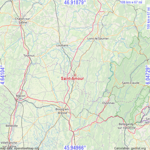
Saint-Amour GPS coordinates[2]
46° 26' 10.968" North, 5° 20' 38.976" East
| Map corner | latitude | longitude |
|---|---|---|
| Upper-left | 46.91879°, | 4.64104° |
| Center: | 46.43638°, | 5.34416° |
| Lower-right: | 45.94966°, | 6.04729° |
| Map W x H: | 107.8×107.8 km | = 67×67mi |
| max Lat: | 51.07786° ⇑60.7% North |
| Saint-Amour: | 46.43638° |
| min Lat: | ⇓39.3% South 41.3874° |
| min Long | Saint-Amour | max Long |
| -5.08615° | 5.34416° | 9.52242° |
| W 81%⇐ | ⇒19% E |
Elevation
Elevation of Saint-Amour is 256 m = 840 ft, and this is 62.3 m = 204 ft above average elevation for this country.
| Max E: |
2333 m = 7654 ft | 24.1% |
| Saint-Amour | 256 m 840 ft | |
| Avg. | 193.7 m = 635 ft | |
Min E: |
-1 m = -3 ft | 75.9% |
See also: France elevation on elevation.city.
Geographical zone
Saint-Amour is located in North temperate zone (between Tropic of Cancer and the Arctic Circle). Distance of this North polar circle is 2237.9 km =1390.6 mi to North.| Distance of | km | miles | from Saint-Amour |
|---|---|---|---|
| North Pole | 4843.8 | 3009.8 | to North |
| Arctic Circle | 2237.9 | 1390.6 | to North |
| Tropic Cancer | 2557.3 | 1589 | to South |
| Equator | 5163.2 | 3208.3 | to South |


Nearby cities:
15 places around Saint-Amour: (largest is in red/bold)
• Beaupont
7 km =4.3 mi,  245°
245°
• Bény
13.3 km =8.3 mi,  199°
199°
• Coligny
6 km =3.7 mi,  178°
178°
• Cormoz
8.8 km =5.5 mi,  279°
279°
• Cousance
11.4 km =7.1 mi,  18°
18°
• Cuiseaux
7.4 km =4.6 mi,  28°
28°
• Cuisiat
15.5 km =9.6 mi,  167°
167°
• Dommartin-lès-Cuiseaux
7.7 km =4.8 mi,  333°
333°
• Foissiat
14.8 km =9.2 mi,  240°
240°
• Frontenaud
13.5 km =8.4 mi,  342°
342°
• Lescheroux
15.7 km =9.8 mi,  257°
257°
• Marboz
12.3 km =7.6 mi,  212°
212°
• Saint-Nizier-le-Bouchoux
15.1 km =9.4 mi, 280°
• Varennes-Saint-Sauveur
9.2 km =5.7 mi,  303°
303°
• Villemotier
10.1 km =6.3 mi,  189°
189°
Sources, notices
• [Note1] Compared only with cities in France existing in our database
• [Src1] Map data: © OpenStreetMap contributors (CC-BY-SA)
• [Src2] Other city data from geonames.org with taken over terms of usage.
• [Src3] Geographical zone / Annual Mean Temperature by Robert A. Rohde @ Wikipedia
