Saint-Nizier-le-Bouchoux geodata
Saint-Nizier-le-Bouchoux (Auvergne-Rhône-Alpes) is a populated place; located in France in Europe/Paris (GMT+2) time zone. With population of 597 people, there are 13370 cities with bigger population in this country. Compared to other cities in France, 60.5% of cities are located further ↑North; 79.3% of cities are located further ←West and 69.2% of cities have lower elevation than Saint-Nizier-le-Bouchoux. Note1
Administrative division(s):
- Level 1: Auvergne-Rhône-Alpes
- Level 2: Département de l'Ain
- Level 3: Arrondissement de Bourg-en-Bresse
- Level 4: Saint-Nizier-le-Bouchoux
Current local time in Saint-Nizier-le-Bouchoux:
05:41 PM, SaturdayDifference from your time zone: hours


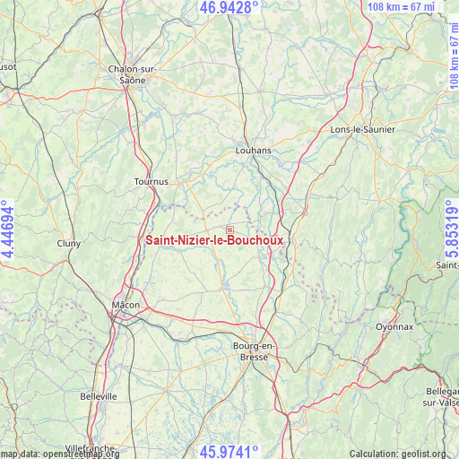
Saint-Nizier-le-Bouchoux GPS coordinates[2]
46° 27' 38.16" North, 5° 9' 0.216" East
| Map corner | latitude | longitude |
|---|---|---|
| Upper-left | 46.9428°, | 4.44694° |
| Center: | 46.4606°, | 5.15006° |
| Lower-right: | 45.9741°, | 5.85319° |
| Map W x H: | 107.7×107.7 km | = 66.9×66.9mi |
| max Lat: | 51.07786° ⇑60.5% North |
| Saint-Nizier-le-Bouchoux: | 46.4606° |
| min Lat: | ⇓39.5% South 41.3874° |
| min Long | Saint-Nizier-le | max Long |
| -5.08615° | 5.15006° | 9.52242° |
| W 79.3%⇐ | ⇒20.7% E |
Elevation
Elevation of Saint-Nizier-le-Bouchoux is 215 m = 705 ft, and this is 21.3 m = 70 ft above average elevation for this country.
| Max E: |
2333 m = 7654 ft | 30.8% |
| Saint-Nizier-le-Bouchoux | 215 m 705 ft | |
| Avg. | 193.7 m = 635 ft | |
Min E: |
-1 m = -3 ft | 69.2% |
See also: France elevation on elevation.city.
Geographical zone
Saint-Nizier-le-Bouchoux is located in North temperate zone (between Tropic of Cancer and the Arctic Circle). Distance of this North polar circle is 2235.2 km =1388.9 mi to North.| Distance of | km | miles | from Saint-Nizier-le-Bouchoux |
|---|---|---|---|
| North Pole | 4841.1 | 3008.1 | to North |
| Arctic Circle | 2235.2 | 1388.9 | to North |
| Tropic Cancer | 2560 | 1590.7 | to South |
| Equator | 5165.9 | 3209.9 | to South |


Nearby cities:
15 places around Saint-Nizier-le-Bouchoux: (largest is in red/bold)
• Beaupont
10.2 km =6.3 mi,  123°
123°
• Chavannes-sur-Reyssouze
12.2 km =7.6 mi,  254°
254°
• Cormoz
6.3 km =3.9 mi,  101°
101°
• Dommartin-lès-Cuiseaux
12.2 km =7.6 mi,  69°
69°
• Foissiat
10.1 km =6.3 mi,  168°
168°
• Jayat
10.4 km =6.5 mi,  193°
193°
• Lescheroux
6.1 km =3.8 mi,  184°
184°
• Montpont-en-Bresse
10.7 km =6.6 mi,  5°
5°
• Romenay
7.7 km =4.8 mi,  306°
306°
• Saint-Bénigne
13.9 km =8.6 mi,  260°
260°
• Saint-Jean-sur-Reyssouze
9.9 km =6.2 mi,  223°
223°
• Saint-Julien-sur-Reyssouze
7.1 km =4.4 mi,  206°
206°
• Saint-Trivier-de-Courtes
5.5 km =3.4 mi,  269°
269°
• Sermoyer
13.8 km =8.6 mi,  288°
288°
• Varennes-Saint-Sauveur
7.5 km =4.7 mi, 71°
Sources, notices
• [Note1] Compared only with cities in France existing in our database
• [Src1] Map data: © OpenStreetMap contributors (CC-BY-SA)
• [Src2] Other city data from geonames.org with taken over terms of usage.
• [Src3] Geographical zone / Annual Mean Temperature by Robert A. Rohde @ Wikipedia
