Cuiseaux geodata
Cuiseaux (Bourgogne-Franche-Comté) is a populated place; located in France in Europe/Paris (GMT+2) time zone. With population of 1,762 people, there are 5373 cities with bigger population in this country. Compared to other cities in France, 60.2% of cities are located further ↑North; 81.8% of cities are located further ←West and 79.3% of cities have lower elevation than Cuiseaux. Note1
Administrative division(s):
- Level 1: Bourgogne-Franche-Comté
- Level 2: Département de Saône-et-Loire
- Level 3: Arrondissement de Louhans
- Level 4: Cuiseaux


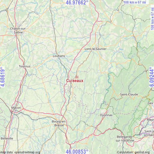
Cuiseaux GPS coordinates[2]
46° 29' 41.028" North, 5° 23' 21.516" East
| Map corner | latitude | longitude |
|---|---|---|
| Upper-left | 46.97662°, | 4.68619° |
| Center: | 46.49473°, | 5.38931° |
| Lower-right: | 46.00853°, | 6.09244° |
| Map W x H: | 107.6×107.6 km | = 66.9×66.9mi |
| max Lat: | 51.07786° ⇑60.2% North |
| Cuiseaux: | 46.49473° |
| min Lat: | ⇓39.8% South 41.3874° |
| min Long | Cuiseaux | max Long |
| -5.08615° | 5.38931° | 9.52242° |
| W 81.8%⇐ | ⇒18.2% E |
Elevation
Elevation of Cuiseaux is 283 m = 928 ft, and this is 89.3 m = 293 ft above average elevation for this country.
| Max E: |
2333 m = 7654 ft | 20.7% |
| Cuiseaux | 283 m 928 ft | |
| Avg. | 193.7 m = 635 ft | |
Min E: |
-1 m = -3 ft | 79.3% |
See also: France elevation on elevation.city.
Geographical zone
Cuiseaux is located in North temperate zone (between Tropic of Cancer and the Arctic Circle). Distance of this North polar circle is 2231.4 km =1386.5 mi to North.| Distance of | km | miles | from Cuiseaux |
|---|---|---|---|
| North Pole | 4837.3 | 3005.8 | to North |
| Arctic Circle | 2231.4 | 1386.5 | to North |
| Tropic Cancer | 2563.8 | 1593.1 | to South |
| Equator | 5169.7 | 3212.3 | to South |


Nearby cities:
15 places around Cuiseaux: (largest is in red/bold)
• Arinthod
17.6 km =10.9 mi,  129°
129°
• Beaufort
9.5 km =5.9 mi,  23°
23°
• Beaupont
13.6 km =8.5 mi,  226°
226°
• Bruailles
16.3 km =10.1 mi,  313°
313°
• Coligny
12.9 km =8 mi,  195°
195°
• Cormoz
13.2 km =8.2 mi,  247°
247°
• Cousance
4.3 km =2.7 mi,  2°
2°
• Dommartin-lès-Cuiseaux
6.9 km =4.3 mi,  273°
273°
• Frontenaud
9.8 km =6.1 mi, 310°
• Orgelet
17.2 km =10.7 mi,  80°
80°
• Sagy
13.3 km =8.3 mi,  333°
333°
• Saint-Amour
7.4 km =4.6 mi,  208°
208°
• Savigny-en-Revermont
15.8 km =9.8 mi,  8°
8°
• Varennes-Saint-Sauveur
11.2 km =7 mi,  262°
262°
• Villemotier
17.3 km =10.7 mi, 197°
Sources, notices
• [Note1] Compared only with cities in France existing in our database
• [Src1] Map data: © OpenStreetMap contributors (CC-BY-SA)
• [Src2] Other city data from geonames.org with taken over terms of usage.
• [Src3] Geographical zone / Annual Mean Temperature by Robert A. Rohde @ Wikipedia
