Saint-Amand geodata
Saint-Amand (Nouvelle-Aquitaine) is a populated place; located in France in Europe/Paris (GMT+2) time zone. With population of 528 people, there are 14653 cities with bigger population in this country. Compared to other cities in France, 66.5% of cities are located further ↑North; 54.3% of cities are located further →East and 94.1% of cities have lower elevation than Saint-Amand. Note1
Administrative division(s):
- Level 1: Nouvelle-Aquitaine
- Level 2: Creuse
- Level 3: Aubusson
- Level 4: Saint-Amand


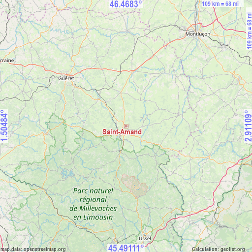
Saint-Amand GPS coordinates[2]
45° 58' 54.696" North, 2° 12' 28.656" East
| Map corner | latitude | longitude |
|---|---|---|
| Upper-left | 46.4683°, | 1.50484° |
| Center: | 45.98186°, | 2.20796° |
| Lower-right: | 45.49111°, | 2.91109° |
| Map W x H: | 108.7×108.7 km | = 67.5×67.5mi |
| max Lat: | 51.07786° ⇑66.5% North |
| Saint-Amand: | 45.98186° |
| min Lat: | ⇓33.5% South 41.3874° |
| min Long | Saint-Amand | max Long |
| -5.08615° | 2.20796° | 9.52242° |
| W 45.7%⇐ | ⇒54.3% E |
Elevation
Elevation of Saint-Amand is 546 m = 1791 ft, and this is 352.3 m = 1156 ft above average elevation for this country.
| Max E: |
2333 m = 7654 ft | 5.9% |
| Saint-Amand | 546 m 1791 ft | |
| Avg. | 193.7 m = 635 ft | |
Min E: |
-1 m = -3 ft | 94.1% |
See also: France elevation on elevation.city.
Geographical zone
Saint-Amand is located in North temperate zone (between Tropic of Cancer and the Arctic Circle). Distance of this North polar circle is 2288.5 km =1422 mi to North.| Distance of | km | miles | from Saint-Amand |
|---|---|---|---|
| North Pole | 4894.4 | 3041.2 | to North |
| Arctic Circle | 2288.5 | 1422 | to North |
| Tropic Cancer | 2506.8 | 1557.7 | to South |
| Equator | 5112.7 | 3176.9 | to South |


Nearby cities:
15 places around Saint-Amand: (largest is in red/bold)
• Ahun
17.1 km =10.6 mi,  312°
312°
• Aubusson
4.3 km =2.7 mi,  226°
226°
• Auzances
23.2 km =14.4 mi,  77°
77°
• Banize
16.4 km =10.2 mi,  223°
223°
• Blessac
6.9 km =4.3 mi,  248°
248°
• Chénérailles
14.8 km =9.2 mi,  350°
350°
• Cressat
19.2 km =11.9 mi,  336°
336°
• Crocq
17.8 km =11.1 mi,  135°
135°
• Felletin
11.2 km =7 mi,  193°
193°
• Gouzon
23.5 km =14.6 mi,  5°
5°
• Jarnages
24.3 km =15.1 mi, 336°
• Lavaveix-les-Mines
13.6 km =8.5 mi,  317°
317°
• Mainsat
15.9 km =9.9 mi,  60°
60°
• Mérinchal
22.9 km =14.2 mi,  108°
108°
• Saint-Médard-la-Rochette
8.8 km =5.5 mi,  329°
329°
Sources, notices
• [Note1] Compared only with cities in France existing in our database
• [Src1] Map data: © OpenStreetMap contributors (CC-BY-SA)
• [Src2] Other city data from geonames.org with taken over terms of usage.
• [Src3] Geographical zone / Annual Mean Temperature by Robert A. Rohde @ Wikipedia
