Auzances geodata
Auzances (Nouvelle-Aquitaine) is a populated place; located in France in Europe/Paris (GMT+2) time zone. With population of 1,435 people, there are 6457 cities with bigger population in this country. Compared to other cities in France, 65.9% of cities are located further ↑North; 50.6% of cities are located further ←West and 94.5% of cities have lower elevation than Auzances. Note1
Administrative division(s):
- Level 1: Nouvelle-Aquitaine
- Level 2: Creuse
- Level 3: Aubusson
- Level 4: Auzances


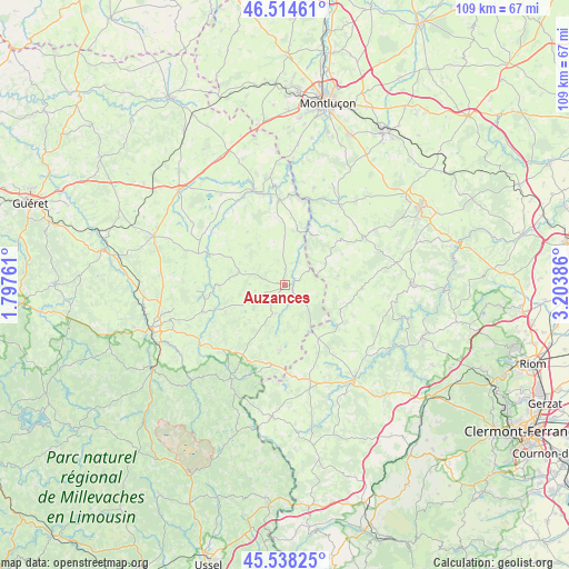
Auzances GPS coordinates[2]
46° 1' 42.924" North, 2° 30' 2.628" East
| Map corner | latitude | longitude |
|---|---|---|
| Upper-left | 46.51461°, | 1.79761° |
| Center: | 46.02859°, | 2.50073° |
| Lower-right: | 45.53825°, | 3.20386° |
| Map W x H: | 108.6×108.6 km | = 67.5×67.5mi |
| max Lat: | 51.07786° ⇑65.9% North |
| Auzances: | 46.02859° |
| min Lat: | ⇓34.1% South 41.3874° |
| min Long | Auzances | max Long |
| -5.08615° | 2.50073° | 9.52242° |
| W 50.6%⇐ | ⇒49.4% E |
Elevation
Elevation of Auzances is 561 m = 1841 ft, and this is 367.3 m = 1205 ft above average elevation for this country.
| Max E: |
2333 m = 7654 ft | 5.5% |
| Auzances | 561 m 1841 ft | |
| Avg. | 193.7 m = 635 ft | |
Min E: |
-1 m = -3 ft | 94.5% |
See also: France elevation on elevation.city.
Geographical zone
Auzances is located in North temperate zone (between Tropic of Cancer and the Arctic Circle). Distance of this North polar circle is 2283.3 km =1418.8 mi to North.| Distance of | km | miles | from Auzances |
|---|---|---|---|
| North Pole | 4889.2 | 3038 | to North |
| Arctic Circle | 2283.3 | 1418.8 | to North |
| Tropic Cancer | 2512 | 1560.9 | to South |
| Equator | 5117.9 | 3180.1 | to South |


Nearby cities:
15 places around Auzances: (largest is in red/bold)
• Budelière
21.5 km =13.4 mi,  353°
353°
• Chambon-sur-Voueize
18.9 km =11.7 mi,  341°
341°
• Charensat
11.5 km =7.1 mi,  114°
114°
• Crocq
20.6 km =12.8 mi,  209°
209°
• Giat
25.3 km =15.7 mi,  185°
185°
• Mainsat
9.2 km =5.7 mi,  286°
286°
• Marcillat-en-Combraille
18.5 km =11.5 mi,  33°
33°
• Mérinchal
12.5 km =7.8 mi,  184°
184°
• Pionsat
17.4 km =10.8 mi,  58°
58°
• Pontaumur
22.3 km =13.9 mi,  142°
142°
• Saint-Amand
23.2 km =14.4 mi,  257°
257°
• Saint-Gervais-d’Auvergne
24.6 km =15.3 mi,  89°
89°
• Saint-Priest-des-Champs
20.7 km =12.9 mi,  101°
101°
• Youx
26.4 km =16.4 mi, 60°
• Évaux-les-Bains
16.3 km =10.1 mi,  355°
355°
Sources, notices
• [Note1] Compared only with cities in France existing in our database
• [Src1] Map data: © OpenStreetMap contributors (CC-BY-SA)
• [Src2] Other city data from geonames.org with taken over terms of usage.
• [Src3] Geographical zone / Annual Mean Temperature by Robert A. Rohde @ Wikipedia
