Mérinchal geodata
Mérinchal (Nouvelle-Aquitaine) is a populated place; located in France in Europe/Paris (GMT+2) time zone. With population of 827 people, there are 10320 cities with bigger population in this country. Compared to other cities in France, 67.4% of cities are located further ↑North; 50.4% of cities are located further ←West and 96.8% of cities have lower elevation than Mérinchal. Note1
Administrative division(s):
- Level 1: Nouvelle-Aquitaine
- Level 2: Creuse
- Level 3: Aubusson
- Level 4: Mérinchal


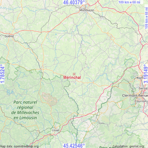
Mérinchal GPS coordinates[2]
45° 55' 0.408" North, 2° 29' 18.096" East
| Map corner | latitude | longitude |
|---|---|---|
| Upper-left | 46.40379°, | 1.78524° |
| Center: | 45.91678°, | 2.48836° |
| Lower-right: | 45.42546°, | 3.19149° |
| Map W x H: | 108.8×108.8 km | = 67.6×67.6mi |
| max Lat: | 51.07786° ⇑67.4% North |
| Mérinchal: | 45.91678° |
| min Lat: | ⇓32.6% South 41.3874° |
| min Long | Mérinchal | max Long |
| -5.08615° | 2.48836° | 9.52242° |
| W 50.4%⇐ | ⇒49.6% E |
Elevation
Elevation of Mérinchal is 708 m = 2323 ft, and this is 514.3 m = 1687 ft above average elevation for this country.
| Max E: |
2333 m = 7654 ft | 3.2% |
| Mérinchal | 708 m 2323 ft | |
| Avg. | 193.7 m = 635 ft | |
Min E: |
-1 m = -3 ft | 96.8% |
See also: France elevation on elevation.city.
Geographical zone
Mérinchal is located in North temperate zone (between Tropic of Cancer and the Arctic Circle). Distance of this North polar circle is 2295.7 km =1426.5 mi to North.| Distance of | km | miles | from Mérinchal |
|---|---|---|---|
| North Pole | 4901.6 | 3045.7 | to North |
| Arctic Circle | 2295.7 | 1426.5 | to North |
| Tropic Cancer | 2499.5 | 1553.1 | to South |
| Equator | 5105.5 | 3172.4 | to South |


Nearby cities:
15 places around Mérinchal: (largest is in red/bold)
• Aubusson
25.2 km =15.7 mi,  279°
279°
• Auzances
12.5 km =7.8 mi,  4°
4°
• Charensat
13.8 km =8.6 mi,  55°
55°
• Crocq
10.8 km =6.7 mi,  239°
239°
• Felletin
24.6 km =15.3 mi,  261°
261°
• Gelles
26.9 km =16.7 mi,  127°
127°
• Giat
12.9 km =8 mi,  187°
187°
• La Goutelle
22.5 km =14 mi,  111°
111°
• Les Ancizes
25.1 km =15.6 mi,  87°
87°
• Mainsat
17 km =10.6 mi,  332°
332°
• Pionsat
26.6 km =16.5 mi,  36°
36°
• Pontaumur
15.4 km =9.6 mi, 110°
• Saint-Amand
22.9 km =14.2 mi,  288°
288°
• Saint-Georges-de-Mons
27.2 km =16.9 mi,  84°
84°
• Saint-Priest-des-Champs
22.9 km =14.2 mi,  68°
68°
Sources, notices
• [Note1] Compared only with cities in France existing in our database
• [Src1] Map data: © OpenStreetMap contributors (CC-BY-SA)
• [Src2] Other city data from geonames.org with taken over terms of usage.
• [Src3] Geographical zone / Annual Mean Temperature by Robert A. Rohde @ Wikipedia
