Roussillon geodata
Roussillon (Auvergne-Rhône-Alpes) is a populated place; located in France in Europe/Paris (GMT+2) time zone. With population of 8,082 people, there are 1202 cities with bigger population in this country. Compared to other cities in France, 75.6% of cities are located further ↑North; 75.3% of cities are located further ←West and 69.9% of cities have lower elevation than Roussillon. Note1
Administrative division(s):
- Level 1: Auvergne-Rhône-Alpes
- Level 2: Département de l'Isère
- Level 3: Arrondissement de Vienne
- Level 4: Roussillon


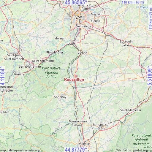
Roussillon GPS coordinates[2]
45° 22' 25.968" North, 4° 48' 53.856" East
| Map corner | latitude | longitude |
|---|---|---|
| Upper-left | 45.86565°, | 4.11184° |
| Center: | 45.37388°, | 4.81496° |
| Lower-right: | 44.87779°, | 5.51809° |
| Map W x H: | 109.8×109.8 km | = 68.2×68.2mi |
| max Lat: | 51.07786° ⇑75.6% North |
| Roussillon: | 45.37388° |
| min Lat: | ⇓24.4% South 41.3874° |
| min Long | Roussillon | max Long |
| -5.08615° | 4.81496° | 9.52242° |
| W 75.3%⇐ | ⇒24.7% E |
Elevation
Elevation of Roussillon is 219 m = 719 ft, and this is 25.3 m = 83 ft above average elevation for this country.
| Max E: |
2333 m = 7654 ft | 30.1% |
| Roussillon | 219 m 719 ft | |
| Avg. | 193.7 m = 635 ft | |
Min E: |
-1 m = -3 ft | 69.9% |
See also: France elevation on elevation.city.
Geographical zone
Roussillon is located in North temperate zone (between Tropic of Cancer and the Arctic Circle). Distance of this North polar circle is 2356.1 km =1464 mi to North.| Distance of | km | miles | from Roussillon |
|---|---|---|---|
| North Pole | 4962 | 3083.2 | to North |
| Arctic Circle | 2356.1 | 1464 | to North |
| Tropic Cancer | 2439.2 | 1515.6 | to South |
| Equator | 5045.1 | 3134.9 | to South |


Nearby cities:
15 places around Roussillon: (largest is in red/bold)
• Agnin
4.8 km =3 mi,  141°
141°
• Anjou
6.1 km =3.8 mi,  117°
117°
• Assieu
4.9 km =3 mi,  45°
45°
• Auberives-sur-Varèze
5.2 km =3.2 mi,  3°
3°
• Chanas
6.1 km =3.8 mi,  177°
177°
• Charnas
7 km =4.3 mi,  233°
233°
• Cheyssieu
6.3 km =3.9 mi,  17°
17°
• Clonas-sur-Varèze
4.8 km =3 mi,  336°
336°
• Le Péage-de-Roussillon
1.4 km =0.9 mi,  269°
269°
• Limony
5.1 km =3.2 mi,  241°
241°
• Sablons
6.7 km =4.2 mi,  208°
208°
• Saint-Alban-du-Rhône
6.9 km =4.3 mi,  320°
320°
• Saint-Pierre-de-Bœuf
5.1 km =3.2 mi,  261°
261°
• Salaise-sur-Sanne
2.5 km =1.6 mi,  187°
187°
• Ville-sous-Anjou
2.8 km =1.7 mi,  92°
92°
Sources, notices
• [Note1] Compared only with cities in France existing in our database
• [Src1] Map data: © OpenStreetMap contributors (CC-BY-SA)
• [Src2] Other city data from geonames.org with taken over terms of usage.
• [Src3] Geographical zone / Annual Mean Temperature by Robert A. Rohde @ Wikipedia
