Cheyssieu geodata
Cheyssieu (Auvergne-Rhône-Alpes) is a populated place; located in France in Europe/Paris (GMT+2) time zone. With population of 800 people, there are 10613 cities with bigger population in this country. Compared to other cities in France, 74.9% of cities are located further ↑North; 75.6% of cities are located further ←West and 70.9% of cities have lower elevation than Cheyssieu. Note1
Administrative division(s):
- Level 1: Auvergne-Rhône-Alpes
- Level 2: Département de l'Isère
- Level 3: Arrondissement de Vienne
- Level 4: Cheyssieu


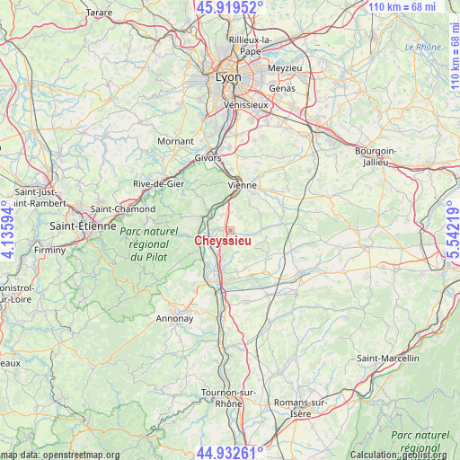
Cheyssieu GPS coordinates[2]
45° 25' 41.592" North, 4° 50' 20.652" East
| Map corner | latitude | longitude |
|---|---|---|
| Upper-left | 45.91952°, | 4.13594° |
| Center: | 45.42822°, | 4.83907° |
| Lower-right: | 44.93261°, | 5.54219° |
| Map W x H: | 109.7×109.7 km | = 68.2×68.2mi |
| max Lat: | 51.07786° ⇑74.9% North |
| Cheyssieu: | 45.42822° |
| min Lat: | ⇓25.1% South 41.3874° |
| min Long | Cheyssieu | max Long |
| -5.08615° | 4.83907° | 9.52242° |
| W 75.6%⇐ | ⇒24.4% E |
Elevation
Elevation of Cheyssieu is 223 m = 732 ft, and this is 29.3 m = 96 ft above average elevation for this country.
| Max E: |
2333 m = 7654 ft | 29.1% |
| Cheyssieu | 223 m 732 ft | |
| Avg. | 193.7 m = 635 ft | |
Min E: |
-1 m = -3 ft | 70.9% |
See also: France elevation on elevation.city.
Geographical zone
Cheyssieu is located in North temperate zone (between Tropic of Cancer and the Arctic Circle). Distance of this North polar circle is 2350 km =1460.2 mi to North.| Distance of | km | miles | from Cheyssieu |
|---|---|---|---|
| North Pole | 4955.9 | 3079.5 | to North |
| Arctic Circle | 2350 | 1460.2 | to North |
| Tropic Cancer | 2445.2 | 1519.4 | to South |
| Equator | 5051.1 | 3138.6 | to South |


Nearby cities:
15 places around Cheyssieu: (largest is in red/bold)
• Assieu
3 km =1.9 mi,  148°
148°
• Auberives-sur-Varèze
1.8 km =1.1 mi,  242°
242°
• Clonas-sur-Varèze
4.1 km =2.5 mi,  246°
246°
• Condrieu
6.8 km =4.2 mi,  304°
304°
• La Chapelle-de-Surieu
6.7 km =4.2 mi,  126°
126°
• Le Péage-de-Roussillon
6.9 km =4.3 mi,  208°
208°
• Les Côtes-d'Arey
3.8 km =2.4 mi,  34°
34°
• Les Roches-de-Condrieu
6.2 km =3.9 mi, 295°
• Reventin-Vaugris
4.3 km =2.7 mi,  3°
3°
• Roussillon
6.3 km =3.9 mi,  197°
197°
• Saint-Alban-du-Rhône
6.3 km =3.9 mi,  263°
263°
• Saint-Clair-du-Rhône
5.5 km =3.4 mi,  285°
285°
• Saint-Prim
4.9 km =3 mi, 298°
• Vernioz
3.4 km =2.1 mi,  92°
92°
• Ville-sous-Anjou
6.2 km =3.9 mi,  171°
171°
Sources, notices
• [Note1] Compared only with cities in France existing in our database
• [Src1] Map data: © OpenStreetMap contributors (CC-BY-SA)
• [Src2] Other city data from geonames.org with taken over terms of usage.
• [Src3] Geographical zone / Annual Mean Temperature by Robert A. Rohde @ Wikipedia
