Morannes geodata
Morannes (Pays de la Loire) is a populated place; located in France in Europe/Paris (GMT+2) time zone. With population of 1,679 people, there are 5581 cities with bigger population in this country. Compared to other cities in France, 54.9% of cities are located further ↓South; 82.3% of cities are located further →East and 90.7% of cities have higher elevation than Morannes. Note1
Administrative division(s):
- Level 1: Pays de la Loire
- Level 2: Département de Maine-et-Loire
- Level 3: Angers
- Level 4: Morannes sur Sarthe-Daumeray


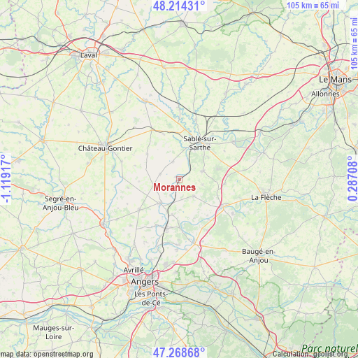
Morannes GPS coordinates[2]
47° 44' 37.104" North, 0° 24' 57.744" West
| Map corner | latitude | longitude |
|---|---|---|
| Upper-left | 48.21431°, | -1.11917° |
| Center: | 47.74364°, | -0.41604° |
| Lower-right: | 47.26868°, | 0.28708° |
| Map W x H: | 105.1×105.1 km | = 65.3×65.3mi |
| max Lat: | 51.07786° ⇑45.1% North |
| Morannes: | 47.74364° |
| min Lat: | ⇓54.9% South 41.3874° |
| min Long | Morannes | max Long |
| -5.08615° | -0.41604° | 9.52242° |
| W 17.7%⇐ | ⇒82.3% E |
Elevation
Elevation of Morannes is 28 m = 92 ft, and this is 165.7 m = 544 ft below average elevation for this country.
| Max E: |
2333 m = 7654 ft | 90.7% |
| Avg. | 193.7 m = 635 ft | |
| Morannes | 28 m = 92 ft | |
Min E: |
-1 m = -3 ft | 9.3% |
See also: France elevation on elevation.city.
Geographical zone
Morannes is located in North temperate zone (between Tropic of Cancer and the Arctic Circle). Distance of this North polar circle is 2092.6 km =1300.3 mi to North.| Distance of | km | miles | from Morannes |
|---|---|---|---|
| North Pole | 4698.5 | 2919.5 | to North |
| Arctic Circle | 2092.6 | 1300.3 | to North |
| Tropic Cancer | 2702.7 | 1679.4 | to South |
| Equator | 5308.6 | 3298.6 | to South |


Nearby cities:
15 places around Morannes: (largest is in red/bold)
• Bierné
12.1 km =7.5 mi,  308°
308°
• Bouère
14 km =8.7 mi,  341°
341°
• Brissarthe
5.4 km =3.4 mi,  207°
207°
• Châteauneuf-sur-Sarthe
8.7 km =5.4 mi,  217°
217°
• Contigné
7.7 km =4.8 mi,  258°
258°
• Courtillers
10.6 km =6.6 mi,  53°
53°
• Daumeray
6.3 km =3.9 mi,  139°
139°
• Juigné
3.2 km =2 mi,  149°
149°
• Juvardeil
11.7 km =7.3 mi, 211°
• Louailles
13.4 km =8.3 mi,  66°
66°
• Miré
5.9 km =3.7 mi,  285°
285°
• Précigné
7.3 km =4.5 mi, 69°
• Sablé-sur-Sarthe
12.2 km =7.6 mi,  30°
30°
• Souvigné-sur-Sarthe
9.5 km =5.9 mi,  12°
12°
• Étriché
10.5 km =6.5 mi,  191°
191°
Sources, notices
• [Note1] Compared only with cities in France existing in our database
• [Src1] Map data: © OpenStreetMap contributors (CC-BY-SA)
• [Src2] Other city data from geonames.org with taken over terms of usage.
• [Src3] Geographical zone / Annual Mean Temperature by Robert A. Rohde @ Wikipedia
