Ry geodata
Ry (Normandy) is a populated place; located in France in Europe/Paris (GMT+2) time zone. With population of 625 people, there are 12901 cities with bigger population in this country. Compared to other cities in France, 88.8% of cities are located further ↓South; 65.1% of cities are located further →East and 71.9% of cities have higher elevation than Ry. Note1
Administrative division(s):
- Level 1: Normandy
- Level 2: Seine-Maritime
- Level 3: Arrondissement de Rouen
- Level 4: Ry


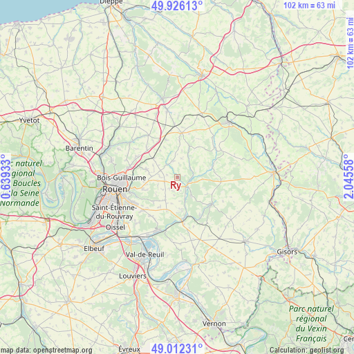
Ry GPS coordinates[2]
49° 28' 16.86" North, 1° 20' 32.82" East
| Map corner | latitude | longitude |
|---|---|---|
| Upper-left | 49.92613°, | 0.63933° |
| Center: | 49.47135°, | 1.34245° |
| Lower-right: | 49.01231°, | 2.04558° |
| Map W x H: | 101.6×101.6 km | = 63.1×63.1mi |
| max Lat: | 51.07786° ⇑11.2% North |
| Ry: | 49.47135° |
| min Lat: | ⇓88.8% South 41.3874° |
| min Long | Ry | max Long |
| -5.08615° | 1.34245° | 9.52242° |
| W 34.9%⇐ | ⇒65.1% E |
Elevation
Elevation of Ry is 74 m = 243 ft, and this is 119.7 m = 393 ft below average elevation for this country.
| Max E: |
2333 m = 7654 ft | 71.9% |
| Avg. | 193.7 m = 635 ft | |
| Ry | 74 m = 243 ft | |
Min E: |
-1 m = -3 ft | 28.1% |
See also: France elevation on elevation.city.
Geographical zone
Ry is located in North temperate zone (between Tropic of Cancer and the Arctic Circle). Distance of this North polar circle is 1900.5 km =1180.9 mi to North.| Distance of | km | miles | from Ry |
|---|---|---|---|
| North Pole | 4506.4 | 2800.1 | to North |
| Arctic Circle | 1900.5 | 1180.9 | to North |
| Tropic Cancer | 2894.8 | 1798.7 | to South |
| Equator | 5500.7 | 3418 | to South |


Nearby cities:
15 places around Ry: (largest is in red/bold)
• Auzouville-sur-Ry
4 km =2.5 mi,  215°
215°
• Blainville-Crevon
4.8 km =3 mi,  319°
319°
• Bourg-Beaudouin
9.7 km =6 mi,  194°
194°
• Catenay
4.7 km =2.9 mi,  347°
347°
• Fresne-le-Plan
7.4 km =4.6 mi,  207°
207°
• Les Hogues
6.4 km =4 mi,  142°
142°
• Martainville-Épreville
3.8 km =2.4 mi,  251°
251°
• Mesnil-Raoul
9.6 km =6 mi, 210°
• Morgny-la-Pommeraye
7.7 km =4.8 mi,  305°
305°
• Perriers-sur-Andelle
6.6 km =4.1 mi,  161°
161°
• Préaux
9.4 km =5.8 mi,  283°
283°
• Saint-Denis-le-Thiboult
2 km =1.2 mi,  131°
131°
• Saint-Lucien
8.7 km =5.4 mi,  61°
61°
• Servaville-Salmonville
5.2 km =3.2 mi, 275°
• Vandrimare
10.2 km =6.3 mi,  179°
179°
Sources, notices
• [Note1] Compared only with cities in France existing in our database
• [Src1] Map data: © OpenStreetMap contributors (CC-BY-SA)
• [Src2] Other city data from geonames.org with taken over terms of usage.
• [Src3] Geographical zone / Annual Mean Temperature by Robert A. Rohde @ Wikipedia
