Mesnil-Raoul geodata
Mesnil-Raoul (Normandy) is a populated place; located in France in Europe/Paris (GMT+2) time zone. With population of 741 people, there are 11277 cities with bigger population in this country. Compared to other cities in France, 87.8% of cities are located further ↓South; 65.9% of cities are located further →East and 56.3% of cities have lower elevation than Mesnil-Raoul. Note1
Administrative division(s):
- Level 1: Normandy
- Level 2: Seine-Maritime
- Level 3: Arrondissement de Rouen
- Level 4: Mesnil-Raoul


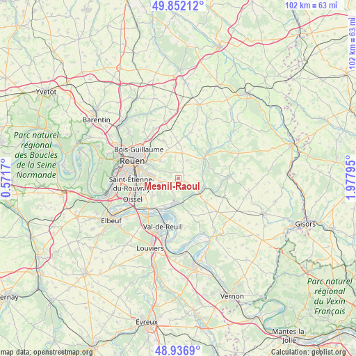
Mesnil-Raoul GPS coordinates[2]
49° 23' 47.904" North, 1° 16' 29.352" East
| Map corner | latitude | longitude |
|---|---|---|
| Upper-left | 49.85212°, | 0.5717° |
| Center: | 49.39664°, | 1.27482° |
| Lower-right: | 48.9369°, | 1.97795° |
| Map W x H: | 101.8×101.8 km | = 63.3×63.3mi |
| max Lat: | 51.07786° ⇑12.2% North |
| Mesnil-Raoul: | 49.39664° |
| min Lat: | ⇓87.8% South 41.3874° |
| min Long | Mesnil-Raoul | max Long |
| -5.08615° | 1.27482° | 9.52242° |
| W 34.1%⇐ | ⇒65.9% E |
Elevation
Elevation of Mesnil-Raoul is 155 m = 509 ft, and this is 38.7 m = 127 ft below average elevation for this country.
| Max E: |
2333 m = 7654 ft | 43.7% |
| Avg. | 193.7 m = 635 ft | |
| Mesnil-Raoul | 155 m = 509 ft | |
Min E: |
-1 m = -3 ft | 56.3% |
See also: France elevation on elevation.city.
Geographical zone
Mesnil-Raoul is located in North temperate zone (between Tropic of Cancer and the Arctic Circle). Distance of this North polar circle is 1908.8 km =1186.1 mi to North.| Distance of | km | miles | from Mesnil-Raoul |
|---|---|---|---|
| North Pole | 4514.7 | 2805.3 | to North |
| Arctic Circle | 1908.8 | 1186.1 | to North |
| Tropic Cancer | 2886.5 | 1793.6 | to South |
| Equator | 5492.4 | 3412.8 | to South |


Nearby cities:
15 places around Mesnil-Raoul: (largest is in red/bold)
• Auzouville-sur-Ry
5.7 km =3.5 mi,  27°
27°
• Boos
5.2 km =3.2 mi,  260°
260°
• Bourg-Beaudouin
2.7 km =1.7 mi,  114°
114°
• Fleury-sur-Andelle
7 km =4.3 mi,  123°
123°
• Fresne-le-Plan
2.3 km =1.4 mi,  41°
41°
• Martainville-Épreville
7.2 km =4.5 mi,  10°
10°
• Montmain
3.1 km =1.9 mi,  298°
298°
• Perriers-sur-Andelle
7.2 km =4.5 mi,  73°
73°
• Pont-Saint-Pierre
6.8 km =4.2 mi,  179°
179°
• Quévreville-la-Poterie
7.7 km =4.8 mi,  233°
233°
• Radepont
6.3 km =3.9 mi,  142°
142°
• Romilly-sur-Andelle
7.3 km =4.5 mi,  187°
187°
• Saint-Aubin-Épinay
8.1 km =5 mi,  285°
285°
• Saint-Jacques-sur-Darnétal
7 km =4.3 mi,  312°
312°
• Vandrimare
5.3 km =3.3 mi, 111°
Sources, notices
• [Note1] Compared only with cities in France existing in our database
• [Src1] Map data: © OpenStreetMap contributors (CC-BY-SA)
• [Src2] Other city data from geonames.org with taken over terms of usage.
• [Src3] Geographical zone / Annual Mean Temperature by Robert A. Rohde @ Wikipedia
