Rupt-sur-Moselle geodata
Rupt-sur-Moselle (Grand Est) is a populated place; located in France in Europe/Paris (GMT+2) time zone. With population of 3,707 people, there are 2653 cities with bigger population in this country. Compared to other cities in France, 58% of cities are located further ↓South; 92.8% of cities are located further ←West and 89.9% of cities have lower elevation than Rupt-sur-Moselle. Note1
Administrative division(s):
- Level 1: Grand Est
- Level 2: Vosges
- Level 3: Arrondissement d’Épinal
- Level 4: Rupt-sur-Moselle


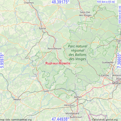
Rupt-sur-Moselle GPS coordinates[2]
47° 55' 21.756" North, 6° 39' 46.476" East
| Map corner | latitude | longitude |
|---|---|---|
| Upper-left | 48.39175°, | 5.95978° |
| Center: | 47.92271°, | 6.66291° |
| Lower-right: | 47.44938°, | 7.36603° |
| Map W x H: | 104.8×104.8 km | = 65.1×65.1mi |
| max Lat: | 51.07786° ⇑42% North |
| Rupt-sur-Moselle: | 47.92271° |
| min Lat: | ⇓58% South 41.3874° |
| min Long | Rupt-sur-Mosell | max Long |
| -5.08615° | 6.66291° | 9.52242° |
| W 92.8%⇐ | ⇒7.2% E |
Elevation
Elevation of Rupt-sur-Moselle is 424 m = 1391 ft, and this is 230.3 m = 756 ft above average elevation for this country.
| Max E: |
2333 m = 7654 ft | 10.1% |
| Rupt-sur-Moselle | 424 m 1391 ft | |
| Avg. | 193.7 m = 635 ft | |
Min E: |
-1 m = -3 ft | 89.9% |
See also: France elevation on elevation.city.
Geographical zone
Rupt-sur-Moselle is located in North temperate zone (between Tropic of Cancer and the Arctic Circle). Distance of this North polar circle is 2072.7 km =1287.9 mi to North.| Distance of | km | miles | from Rupt-sur-Moselle |
|---|---|---|---|
| North Pole | 4678.6 | 2907.1 | to North |
| Arctic Circle | 2072.7 | 1287.9 | to North |
| Tropic Cancer | 2722.6 | 1691.7 | to South |
| Equator | 5328.5 | 3311 | to South |


Nearby cities:
15 places around Rupt-sur-Moselle: (largest is in red/bold)
• Basse-sur-le-Rupt
9.9 km =6.2 mi,  44°
44°
• Dommartin-lès-Remiremont
8.6 km =5.3 mi,  348°
348°
• Faucogney-et-la-Mer
11.7 km =7.3 mi,  219°
219°
• Ferdrupt
3.9 km =2.4 mi,  117°
117°
• Fresse-sur-Moselle
10.5 km =6.5 mi, 119°
• Le Ménil
9.1 km =5.7 mi,  102°
102°
• Le Syndicat
10.6 km =6.6 mi,  8°
8°
• Le Thillot
8.9 km =5.5 mi, 122°
• Ramonchamp
6.7 km =4.2 mi, 118°
• Saint-Amé
11.2 km =7 mi,  0°
0°
• Saint-Étienne-lès-Remiremont
11.8 km =7.3 mi,  340°
340°
• Saulxures-sur-Moselotte
8.5 km =5.3 mi,  69°
69°
• Thiéfosse
7.3 km =4.5 mi, 43°
• Vagney
10.1 km =6.3 mi,  23°
23°
• Vecoux
6.5 km =4 mi, 342°
Sources, notices
• [Note1] Compared only with cities in France existing in our database
• [Src1] Map data: © OpenStreetMap contributors (CC-BY-SA)
• [Src2] Other city data from geonames.org with taken over terms of usage.
• [Src3] Geographical zone / Annual Mean Temperature by Robert A. Rohde @ Wikipedia
