Vagney geodata
Vagney (Grand Est) is a populated place; located in France in Europe/Paris (GMT+2) time zone. With population of 3,860 people, there are 2547 cities with bigger population in this country. Compared to other cities in France, 59.4% of cities are located further ↓South; 93.1% of cities are located further ←West and 88.9% of cities have lower elevation than Vagney. Note1
Administrative division(s):
- Level 1: Grand Est
- Level 2: Vosges
- Level 3: Arrondissement d’Épinal
- Level 4: Vagney


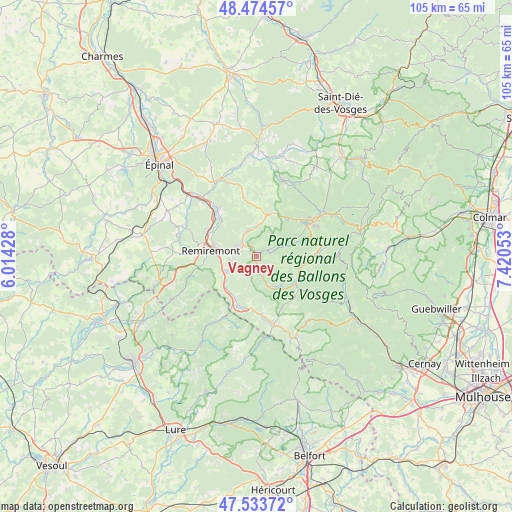
Vagney GPS coordinates[2]
48° 0' 22.644" North, 6° 43' 2.64" East
| Map corner | latitude | longitude |
|---|---|---|
| Upper-left | 48.47457°, | 6.01428° |
| Center: | 48.00629°, | 6.7174° |
| Lower-right: | 47.53372°, | 7.42053° |
| Map W x H: | 104.6×104.6 km | = 65×65mi |
| max Lat: | 51.07786° ⇑40.6% North |
| Vagney: | 48.00629° |
| min Lat: | ⇓59.4% South 41.3874° |
| min Long | Vagney | max Long |
| -5.08615° | 6.7174° | 9.52242° |
| W 93.1%⇐ | ⇒6.9% E |
Elevation
Elevation of Vagney is 406 m = 1332 ft, and this is 212.3 m = 697 ft above average elevation for this country.
| Max E: |
2333 m = 7654 ft | 11.1% |
| Vagney | 406 m 1332 ft | |
| Avg. | 193.7 m = 635 ft | |
Min E: |
-1 m = -3 ft | 88.9% |
See also: France elevation on elevation.city.
Geographical zone
Vagney is located in North temperate zone (between Tropic of Cancer and the Arctic Circle). Distance of this North polar circle is 2063.4 km =1282.1 mi to North.| Distance of | km | miles | from Vagney |
|---|---|---|---|
| North Pole | 4669.3 | 2901.4 | to North |
| Arctic Circle | 2063.4 | 1282.1 | to North |
| Tropic Cancer | 2731.9 | 1697.5 | to South |
| Equator | 5337.8 | 3316.8 | to South |


Nearby cities:
15 places around Vagney: (largest is in red/bold)
• Basse-sur-le-Rupt
3.7 km =2.3 mi,  128°
128°
• Cornimont
9.9 km =6.2 mi,  121°
121°
• Dommartin-lès-Remiremont
5.8 km =3.6 mi,  261°
261°
• La Forge
6.6 km =4.1 mi,  4°
4°
• Le Syndicat
2.7 km =1.7 mi,  296°
296°
• Le Tholy
8.7 km =5.4 mi,  12°
12°
• Remiremont
9.7 km =6 mi,  277°
277°
• Rochesson
5.5 km =3.4 mi,  71°
71°
• Rupt-sur-Moselle
10.1 km =6.3 mi,  203°
203°
• Saint-Amé
4.4 km =2.7 mi, 296°
• Saint-Étienne-lès-Remiremont
8.3 km =5.2 mi, 282°
• Sapois
2.9 km =1.8 mi,  60°
60°
• Saulxures-sur-Moselotte
7.5 km =4.7 mi,  148°
148°
• Thiéfosse
4.1 km =2.5 mi,  165°
165°
• Vecoux
6.8 km =4.2 mi,  242°
242°
Sources, notices
• [Note1] Compared only with cities in France existing in our database
• [Src1] Map data: © OpenStreetMap contributors (CC-BY-SA)
• [Src2] Other city data from geonames.org with taken over terms of usage.
• [Src3] Geographical zone / Annual Mean Temperature by Robert A. Rohde @ Wikipedia
