Ville-sous-Anjou geodata
Ville-sous-Anjou (Auvergne-Rhône-Alpes) is a populated place; located in France in Europe/Paris (GMT+2) time zone. With population of 1,106 people, there are 8091 cities with bigger population in this country. Compared to other cities in France, 75.6% of cities are located further ↑North; 75.9% of cities are located further ←West and 73.3% of cities have lower elevation than Ville-sous-Anjou. Note1
Administrative division(s):
- Level 1: Auvergne-Rhône-Alpes
- Level 2: Département de l'Isère
- Level 3: Arrondissement de Vienne
- Level 4: Ville-sous-Anjou


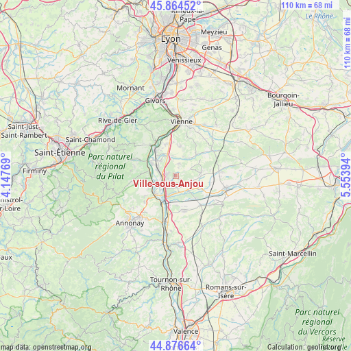
Ville-sous-Anjou GPS coordinates[2]
45° 22' 21.864" North, 4° 51' 2.916" East
| Map corner | latitude | longitude |
|---|---|---|
| Upper-left | 45.86452°, | 4.14769° |
| Center: | 45.37274°, | 4.85081° |
| Lower-right: | 44.87664°, | 5.55394° |
| Map W x H: | 109.8×109.8 km | = 68.2×68.2mi |
| max Lat: | 51.07786° ⇑75.6% North |
| Ville-sous-Anjou: | 45.37274° |
| min Lat: | ⇓24.4% South 41.3874° |
| min Long | Ville-sous-Anjo | max Long |
| -5.08615° | 4.85081° | 9.52242° |
| W 75.9%⇐ | ⇒24.1% E |
Elevation
Elevation of Ville-sous-Anjou is 238 m = 781 ft, and this is 44.3 m = 145 ft above average elevation for this country.
| Max E: |
2333 m = 7654 ft | 26.7% |
| Ville-sous-Anjou | 238 m 781 ft | |
| Avg. | 193.7 m = 635 ft | |
Min E: |
-1 m = -3 ft | 73.3% |
See also: France elevation on elevation.city.
Geographical zone
Ville-sous-Anjou is located in North temperate zone (between Tropic of Cancer and the Arctic Circle). Distance of this North polar circle is 2356.2 km =1464.1 mi to North.| Distance of | km | miles | from Ville-sous-Anjou |
|---|---|---|---|
| North Pole | 4962.1 | 3083.3 | to North |
| Arctic Circle | 2356.2 | 1464.1 | to North |
| Tropic Cancer | 2439.1 | 1515.6 | to South |
| Equator | 5045 | 3134.8 | to South |


Nearby cities:
15 places around Ville-sous-Anjou: (largest is in red/bold)
• Agnin
3.6 km =2.2 mi,  176°
176°
• Anjou
3.7 km =2.3 mi,  135°
135°
• Assieu
3.7 km =2.3 mi,  11°
11°
• Auberives-sur-Varèze
5.9 km =3.7 mi,  335°
335°
• Bougé-Chambalud
6.1 km =3.8 mi, 140°
• Chanas
6.5 km =4 mi,  202°
202°
• Cheyssieu
6.2 km =3.9 mi,  351°
351°
• Clonas-sur-Varèze
6.5 km =4 mi,  314°
314°
• La Chapelle-de-Surieu
4.9 km =3 mi,  63°
63°
• Le Péage-de-Roussillon
4.2 km =2.6 mi,  271°
271°
• Limony
7.6 km =4.7 mi,  252°
252°
• Roussillon
2.8 km =1.7 mi, 272°
• Salaise-sur-Sanne
3.9 km =2.4 mi,  232°
232°
• Sonnay
4.5 km =2.8 mi,  111°
111°
• Vernioz
6.5 km =4 mi,  22°
22°
Sources, notices
• [Note1] Compared only with cities in France existing in our database
• [Src1] Map data: © OpenStreetMap contributors (CC-BY-SA)
• [Src2] Other city data from geonames.org with taken over terms of usage.
• [Src3] Geographical zone / Annual Mean Temperature by Robert A. Rohde @ Wikipedia
