Roncey geodata
Roncey (Normandy) is a populated place; located in France in Europe/Paris (GMT+2) time zone. With population of 828 people, there are 10310 cities with bigger population in this country. Compared to other cities in France, 79.5% of cities are located further ↓South; 91% of cities are located further →East and 65.3% of cities have higher elevation than Roncey. Note1
Administrative division(s):
- Level 1: Normandy
- Level 2: Manche
- Level 3: Arrondissement de Coutances
- Level 4: Roncey


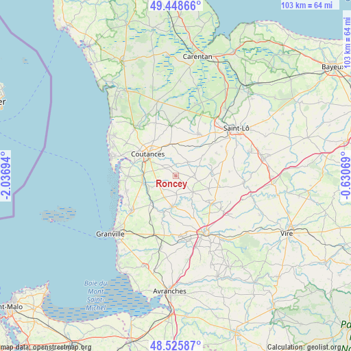
Roncey GPS coordinates[2]
48° 59' 21.84" North, 1° 20' 1.716" West
| Map corner | latitude | longitude |
|---|---|---|
| Upper-left | 49.44866°, | -2.03694° |
| Center: | 48.9894°, | -1.33381° |
| Lower-right: | 48.52587°, | -0.63069° |
| Map W x H: | 102.6×102.6 km | = 63.8×63.8mi |
| max Lat: | 51.07786° ⇑20.5% North |
| Roncey: | 48.9894° |
| min Lat: | ⇓79.5% South 41.3874° |
| min Long | Roncey | max Long |
| -5.08615° | -1.33381° | 9.52242° |
| W 9%⇐ | ⇒91% E |
Elevation
Elevation of Roncey is 89 m = 292 ft, and this is 104.7 m = 344 ft below average elevation for this country.
| Max E: |
2333 m = 7654 ft | 65.3% |
| Avg. | 193.7 m = 635 ft | |
| Roncey | 89 m = 292 ft | |
Min E: |
-1 m = -3 ft | 34.7% |
See also: France elevation on elevation.city.
Geographical zone
Roncey is located in North temperate zone (between Tropic of Cancer and the Arctic Circle). Distance of this North polar circle is 1954.1 km =1214.2 mi to North.| Distance of | km | miles | from Roncey |
|---|---|---|---|
| North Pole | 4560 | 2833.5 | to North |
| Arctic Circle | 1954.1 | 1214.2 | to North |
| Tropic Cancer | 2841.2 | 1765.4 | to South |
| Equator | 5447.1 | 3384.7 | to South |


Nearby cities:
15 places around Roncey: (largest is in red/bold)
• Cambernon
10.8 km =6.7 mi,  339°
339°
• Carantilly
10.9 km =6.8 mi,  38°
38°
• Cerisy-la-Salle
5.5 km =3.4 mi, 42°
• Coutances
10.2 km =6.3 mi,  307°
307°
• Cérences
10.9 km =6.8 mi,  222°
222°
• Dangy
10.1 km =6.3 mi,  52°
52°
• Gavray
8.8 km =5.5 mi,  188°
188°
• Hambye
6.9 km =4.3 mi,  132°
132°
• Montpinchon
4 km =2.5 mi,  25°
25°
• Notre-Dame-de-Cenilly
5.6 km =3.5 mi,  83°
83°
• Orval
10.4 km =6.5 mi,  285°
285°
• Quettreville-sur-Sienne
10.1 km =6.3 mi,  256°
256°
• Saint-Denis-le-Vêtu
5.1 km =3.2 mi,  266°
266°
• Saussey
7.6 km =4.7 mi, 286°
• Trelly
7.5 km =4.7 mi,  244°
244°
Sources, notices
• [Note1] Compared only with cities in France existing in our database
• [Src1] Map data: © OpenStreetMap contributors (CC-BY-SA)
• [Src2] Other city data from geonames.org with taken over terms of usage.
• [Src3] Geographical zone / Annual Mean Temperature by Robert A. Rohde @ Wikipedia
