Saint-Laurent-de-Brévedent geodata
Saint-Laurent-de-Brévedent (Normandy) is a populated place; located in France in Europe/Paris (GMT+2) time zone. With population of 1,530 people, there are 6080 cities with bigger population in this country. Compared to other cities in France, 89.7% of cities are located further ↓South; 75.7% of cities are located further →East and 67% of cities have higher elevation than Saint-Laurent-de-Brévedent. Note1
Administrative division(s):
- Level 1: Normandy
- Level 2: Seine-Maritime
- Level 3: Arrondissement du Havre
- Level 4: Saint-Laurent-de-Brèvedent
Current local time in Saint-Laurent-de-Brévedent:
05:52 AM, WednesdayDifference from your time zone: hours


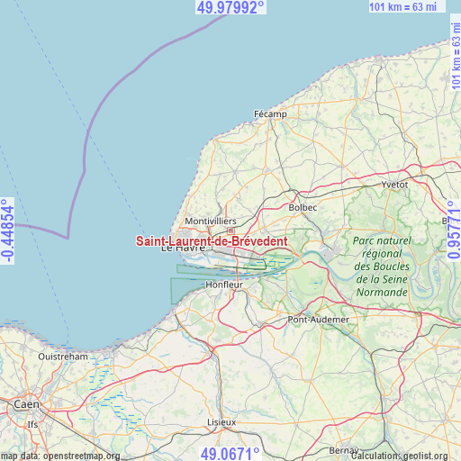
Saint-Laurent-de-Brévedent GPS coordinates[2]
49° 31' 32.304" North, 0° 15' 16.488" East
| Map corner | latitude | longitude |
|---|---|---|
| Upper-left | 49.97992°, | -0.44854° |
| Center: | 49.52564°, | 0.25458° |
| Lower-right: | 49.0671°, | 0.95771° |
| Map W x H: | 101.5×101.5 km | = 63.1×63.1mi |
| max Lat: | 51.07786° ⇑10.3% North |
| Saint-Laurent-de-Brévedent: | 49.52564° |
| min Lat: | ⇓89.7% South 41.3874° |
| min Long | Saint-Laurent-d | max Long |
| -5.08615° | 0.25458° | 9.52242° |
| W 24.3%⇐ | ⇒75.7% E |
Elevation
Elevation of Saint-Laurent-de-Brévedent is 85 m = 279 ft, and this is 108.7 m = 357 ft below average elevation for this country.
| Max E: |
2333 m = 7654 ft | 67% |
| Avg. | 193.7 m = 635 ft | |
| Saint-Laurent-de-Brévedent | 85 m = 279 ft | |
Min E: |
-1 m = -3 ft | 33% |
See also: France elevation on elevation.city.
Geographical zone
Saint-Laurent-de-Brévedent is located in North temperate zone (between Tropic of Cancer and the Arctic Circle). Distance of this North polar circle is 1894.4 km =1177.1 mi to North.| Distance of | km | miles | from Saint-Laurent-de-Brévedent |
|---|---|---|---|
| North Pole | 4500.3 | 2796.4 | to North |
| Arctic Circle | 1894.4 | 1177.1 | to North |
| Tropic Cancer | 2900.8 | 1802.5 | to South |
| Equator | 5506.7 | 3421.7 | to South |


Nearby cities:
15 places around Saint-Laurent-de-Brévedent: (largest is in red/bold)
• Angerville-l’Orcher
7.2 km =4.5 mi,  15°
15°
• Fontenay
6.4 km =4 mi,  306°
306°
• Gainneville
0.9 km =0.6 mi,  147°
147°
• Harfleur
4.6 km =2.9 mi,  242°
242°
• Manéglise
4.5 km =2.8 mi,  1°
1°
• Montivilliers
5.3 km =3.3 mi,  294°
294°
• Rogerville
2.6 km =1.6 mi,  163°
163°
• Rolleville
7 km =4.3 mi,  333°
333°
• Sainneville
4.2 km =2.6 mi,  35°
35°
• Saint-Aubin-Routot
5.2 km =3.2 mi,  92°
92°
• Saint-Martin-du-Manoir
1.4 km =0.9 mi,  300°
300°
• Sandouville
5.5 km =3.4 mi,  124°
124°
• Épouville
4.8 km =3 mi, 332°
• Épretot
4.7 km =2.9 mi,  71°
71°
• Étainhus
6.2 km =3.9 mi, 42°
Sources, notices
• [Note1] Compared only with cities in France existing in our database
• [Src1] Map data: © OpenStreetMap contributors (CC-BY-SA)
• [Src2] Other city data from geonames.org with taken over terms of usage.
• [Src3] Geographical zone / Annual Mean Temperature by Robert A. Rohde @ Wikipedia
