Riom-ès-Montagnes geodata
Riom-ès-Montagnes (Auvergne-Rhône-Alpes) is a populated place; located in France in Europe/Paris (GMT+2) time zone. With population of 2,902 people, there are 3354 cities with bigger population in this country. Compared to other cities in France, 76.5% of cities are located further ↑North; 52.9% of cities are located further ←West and 98.7% of cities have lower elevation than Riom-ès-Montagnes. Note1
Administrative division(s):
- Level 1: Auvergne-Rhône-Alpes
- Level 2: Cantal
- Level 3: Arrondissement de Mauriac
- Level 4: Riom-ès-Montagnes


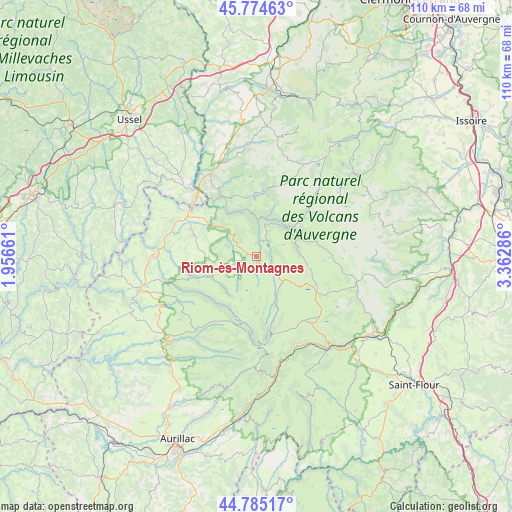
Riom-ès-Montagnes GPS coordinates[2]
45° 16' 55.416" North, 2° 39' 35.028" East
| Map corner | latitude | longitude |
|---|---|---|
| Upper-left | 45.77463°, | 1.95661° |
| Center: | 45.28206°, | 2.65973° |
| Lower-right: | 44.78517°, | 3.36286° |
| Map W x H: | 110×110 km | = 68.4×68.4mi |
| max Lat: | 51.07786° ⇑76.5% North |
| Riom-ès-Montagnes: | 45.28206° |
| min Lat: | ⇓23.5% South 41.3874° |
| min Long | Riom-ès-Montag | max Long |
| -5.08615° | 2.65973° | 9.52242° |
| W 52.9%⇐ | ⇒47.1% E |
Elevation
Elevation of Riom-ès-Montagnes is 912 m = 2992 ft, and this is 718.3 m = 2357 ft above average elevation for this country.
| Max E: |
2333 m = 7654 ft | 1.3% |
| Riom-ès-Montagnes | 912 m 2992 ft | |
| Avg. | 193.7 m = 635 ft | |
Min E: |
-1 m = -3 ft | 98.7% |
See also: France elevation on elevation.city.
Geographical zone
Riom-ès-Montagnes is located in North temperate zone (between Tropic of Cancer and the Arctic Circle). Distance of this North polar circle is 2366.3 km =1470.4 mi to North.| Distance of | km | miles | from Riom-ès-Montagnes |
|---|---|---|---|
| North Pole | 4972.2 | 3089.6 | to North |
| Arctic Circle | 2366.3 | 1470.4 | to North |
| Tropic Cancer | 2429 | 1509.3 | to South |
| Equator | 5034.9 | 3128.5 | to South |


Nearby cities:
15 places around Riom-ès-Montagnes: (largest is in red/bold)
• Allanche
22.3 km =13.9 mi,  105°
105°
• Anglards-de-Salers
19.2 km =11.9 mi,  243°
243°
• Bort-les-Orgues
18.3 km =11.4 mi,  315°
315°
• Champagnac
22 km =13.7 mi,  292°
292°
• Champs-sur-Tarentaine-Marchal
15 km =9.3 mi,  330°
330°
• Condat
10.1 km =6.3 mi,  49°
49°
• Lanobre
20 km =12.4 mi, 330°
• Laveissière
21.8 km =13.5 mi,  147°
147°
• Le Vigean
24.7 km =15.3 mi,  255°
255°
• Marcenat
13.4 km =8.3 mi,  78°
78°
• Menet
6.2 km =3.9 mi, 285°
• Saignes
15.3 km =9.5 mi, 292°
• Trizac
10 km =6.2 mi,  251°
251°
• Ydes
18.8 km =11.7 mi, 292°
• Égliseneuve-d’Entraigues
19.2 km =11.9 mi,  43°
43°
In other languages:
- In France: Riom-ès-Montagnes, Riom-ès-Montagne, Riom
- In Russian: Рьом-эс-Монтань
- In Chinese: 里翁埃蒙塔盖
Sources, notices
• [Note1] Compared only with cities in France existing in our database
• [Src1] Map data: © OpenStreetMap contributors (CC-BY-SA)
• [Src2] Other city data from geonames.org with taken over terms of usage.
• [Src3] Geographical zone / Annual Mean Temperature by Robert A. Rohde @ Wikipedia
