Lanobre geodata
Lanobre (Auvergne-Rhône-Alpes) is a populated place; located in France in Europe/Paris (GMT+2) time zone. With population of 1,443 people, there are 6415 cities with bigger population in this country. Compared to other cities in France, 74.8% of cities are located further ↑North; 51.1% of cities are located further ←West and 96.6% of cities have lower elevation than Lanobre. Note1
Administrative division(s):
- Level 1: Auvergne-Rhône-Alpes
- Level 2: Cantal
- Level 3: Arrondissement de Mauriac
- Level 4: Lanobre


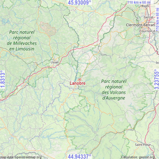
Lanobre GPS coordinates[2]
45° 26' 20.004" North, 2° 32' 3.948" East
| Map corner | latitude | longitude |
|---|---|---|
| Upper-left | 45.93009°, | 1.8313° |
| Center: | 45.43889°, | 2.53443° |
| Lower-right: | 44.94337°, | 3.23755° |
| Map W x H: | 109.7×109.7 km | = 68.2×68.2mi |
| max Lat: | 51.07786° ⇑74.8% North |
| Lanobre: | 45.43889° |
| min Lat: | ⇓25.2% South 41.3874° |
| min Long | Lanobre | max Long |
| -5.08615° | 2.53443° | 9.52242° |
| W 51.1%⇐ | ⇒48.9% E |
Elevation
Elevation of Lanobre is 683 m = 2241 ft, and this is 489.3 m = 1605 ft above average elevation for this country.
| Max E: |
2333 m = 7654 ft | 3.4% |
| Lanobre | 683 m 2241 ft | |
| Avg. | 193.7 m = 635 ft | |
Min E: |
-1 m = -3 ft | 96.6% |
See also: France elevation on elevation.city.
Geographical zone
Lanobre is located in North temperate zone (between Tropic of Cancer and the Arctic Circle). Distance of this North polar circle is 2348.8 km =1459.5 mi to North.| Distance of | km | miles | from Lanobre |
|---|---|---|---|
| North Pole | 4954.7 | 3078.7 | to North |
| Arctic Circle | 2348.8 | 1459.5 | to North |
| Tropic Cancer | 2446.4 | 1520.1 | to South |
| Equator | 5052.3 | 3139.4 | to South |


Nearby cities:
15 places around Lanobre: (largest is in red/bold)
• Bort-les-Orgues
5.3 km =3.3 mi,  214°
214°
• Champagnac
14 km =8.7 mi,  229°
229°
• Champs-sur-Tarentaine-Marchal
5 km =3.1 mi,  149°
149°
• Condat
20.6 km =12.8 mi,  121°
121°
• La Tour-d’Auvergne
16 km =9.9 mi,  48°
48°
• Menet
16.2 km =10.1 mi,  166°
166°
• Messeix
19.8 km =12.3 mi,  1°
1°
• Riom-ès-Montagnes
20 km =12.4 mi, 150°
• Saignes
12.4 km =7.7 mi,  200°
200°
• Saint-Exupéry-les-Roches
15.5 km =9.6 mi,  303°
303°
• Saint-Sauves-d'Auvergne
21.3 km =13.2 mi,  32°
32°
• Tauves
15.1 km =9.4 mi, 27°
• Trizac
20.7 km =12.9 mi,  179°
179°
• Ussel
21.3 km =13.2 mi, 304°
• Ydes
12.7 km =7.9 mi,  216°
216°
Sources, notices
• [Note1] Compared only with cities in France existing in our database
• [Src1] Map data: © OpenStreetMap contributors (CC-BY-SA)
• [Src2] Other city data from geonames.org with taken over terms of usage.
• [Src3] Geographical zone / Annual Mean Temperature by Robert A. Rohde @ Wikipedia
