Trizac geodata
Trizac (Auvergne-Rhône-Alpes) is a populated place; located in France in Europe/Paris (GMT+2) time zone. With population of 662 people, there are 12351 cities with bigger population in this country. Compared to other cities in France, 76.8% of cities are located further ↑North; 51.2% of cities are located further ←West and 99.2% of cities have lower elevation than Trizac. Note1
Administrative division(s):
- Level 1: Auvergne-Rhône-Alpes
- Level 2: Cantal
- Level 3: Arrondissement de Mauriac
- Level 4: Trizac


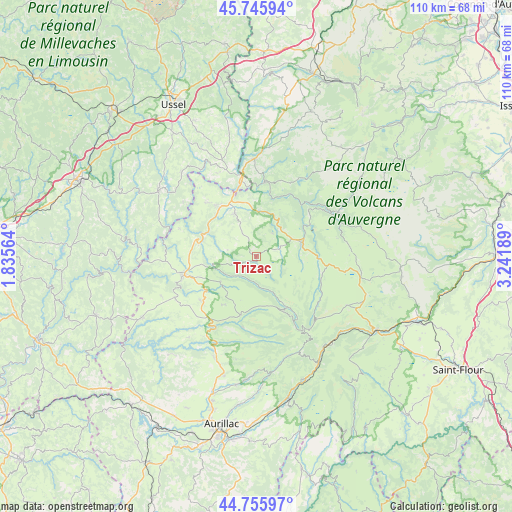
Trizac GPS coordinates[2]
45° 15' 11.196" North, 2° 32' 19.536" East
| Map corner | latitude | longitude |
|---|---|---|
| Upper-left | 45.74594°, | 1.83564° |
| Center: | 45.25311°, | 2.53876° |
| Lower-right: | 44.75597°, | 3.24189° |
| Map W x H: | 110.1×110.1 km | = 68.4×68.4mi |
| max Lat: | 51.07786° ⇑76.8% North |
| Trizac: | 45.25311° |
| min Lat: | ⇓23.2% South 41.3874° |
| min Long | Trizac | max Long |
| -5.08615° | 2.53876° | 9.52242° |
| W 51.2%⇐ | ⇒48.8% E |
Elevation
Elevation of Trizac is 1014 m = 3327 ft, and this is 820.3 m = 2691 ft above average elevation for this country.
| Max E: |
2333 m = 7654 ft | 0.8% |
| Trizac | 1014 m 3327 ft | |
| Avg. | 193.7 m = 635 ft | |
Min E: |
-1 m = -3 ft | 99.2% |
See also: France elevation on elevation.city.
Geographical zone
Trizac is located in North temperate zone (between Tropic of Cancer and the Arctic Circle). Distance of this North polar circle is 2369.5 km =1472.3 mi to North.| Distance of | km | miles | from Trizac |
|---|---|---|---|
| North Pole | 4975.4 | 3091.6 | to North |
| Arctic Circle | 2369.5 | 1472.3 | to North |
| Tropic Cancer | 2425.8 | 1507.3 | to South |
| Equator | 5031.7 | 3126.6 | to South |


Nearby cities:
15 places around Trizac: (largest is in red/bold)
• Anglards-de-Salers
9.4 km =5.8 mi,  235°
235°
• Bort-les-Orgues
16.7 km =10.4 mi,  348°
348°
• Champagnac
15.8 km =9.8 mi,  316°
316°
• Champs-sur-Tarentaine-Marchal
16.5 km =10.3 mi,  7°
7°
• Condat
19.7 km =12.2 mi,  60°
60°
• Lanobre
20.7 km =12.9 mi,  359°
359°
• Le Vigean
14.8 km =9.2 mi,  258°
258°
• Marcenat
23.3 km =14.5 mi,  75°
75°
• Mauriac
16.5 km =10.3 mi, 256°
• Menet
6 km =3.7 mi,  35°
35°
• Riom-ès-Montagnes
10 km =6.2 mi,  71°
71°
• Saignes
10.2 km =6.3 mi,  332°
332°
• Saint-Cernin
23.5 km =14.6 mi,  203°
203°
• Saint-Martin-Valmeroux
17.5 km =10.9 mi,  210°
210°
• Ydes
13.1 km =8.1 mi, 322°
Sources, notices
• [Note1] Compared only with cities in France existing in our database
• [Src1] Map data: © OpenStreetMap contributors (CC-BY-SA)
• [Src2] Other city data from geonames.org with taken over terms of usage.
• [Src3] Geographical zone / Annual Mean Temperature by Robert A. Rohde @ Wikipedia
