Richerenches geodata
Richerenches (Provence-Alpes-Côte d'Azur) is a populated place; located in France in Europe/Paris (GMT+2) time zone. With population of 674 people, there are 12156 cities with bigger population in this country. Compared to other cities in France, 84.5% of cities are located further ↑North; 76.6% of cities are located further ←West and 57.4% of cities have lower elevation than Richerenches. Note1
Administrative division(s):
- Level 1: Provence-Alpes-Côte d'Azur
- Level 2: Département du Vaucluse
- Level 3: Arrondissement de Carpentras
- Level 4: Richerenches


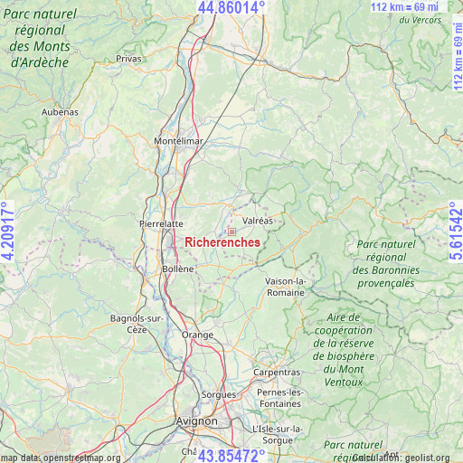
Richerenches GPS coordinates[2]
44° 21' 34.524" North, 4° 54' 44.244" East
| Map corner | latitude | longitude |
|---|---|---|
| Upper-left | 44.86014°, | 4.20917° |
| Center: | 44.35959°, | 4.91229° |
| Lower-right: | 43.85472°, | 5.61542° |
| Map W x H: | 111.8×111.8 km | = 69.5×69.5mi |
| max Lat: | 51.07786° ⇑84.5% North |
| Richerenches: | 44.35959° |
| min Lat: | ⇓15.5% South 41.3874° |
| min Long | Richerenches | max Long |
| -5.08615° | 4.91229° | 9.52242° |
| W 76.6%⇐ | ⇒23.4% E |
Elevation
Elevation of Richerenches is 159 m = 522 ft, and this is 34.7 m = 114 ft below average elevation for this country.
| Max E: |
2333 m = 7654 ft | 42.6% |
| Avg. | 193.7 m = 635 ft | |
| Richerenches | 159 m = 522 ft | |
Min E: |
-1 m = -3 ft | 57.4% |
See also: France elevation on elevation.city.
Geographical zone
Richerenches is located in North temperate zone (between Tropic of Cancer and the Arctic Circle). Distance of this Northern Tropic circle is 2326.4 km =1445.6 mi to South.| Distance of | km | miles | from Richerenches |
|---|---|---|---|
| North Pole | 5074.7 | 3153.3 | to North |
| Arctic Circle | 2468.9 | 1534.1 | to North |
| Tropic Cancer | 2326.4 | 1445.6 | to South |
| Equator | 4932.3 | 3064.8 | to South |


Nearby cities:
15 places around Richerenches: (largest is in red/bold)
• Bouchet
7.3 km =4.5 mi,  204°
204°
• Chamaret
4.9 km =3 mi,  329°
329°
• Grignan
6.7 km =4.2 mi,  356°
356°
• Grillon
4.2 km =2.6 mi,  19°
19°
• La Baume-de-Transit
4.5 km =2.8 mi,  235°
235°
• Montségur-sur-Lauzon
4.6 km =2.9 mi,  271°
271°
• Saint-Maurice-sur-Eygues
10.3 km =6.4 mi,  130°
130°
• Saint-Paul-Trois-Châteaux
11.9 km =7.4 mi,  262°
262°
• Saint-Restitut
10.3 km =6.4 mi,  247°
247°
• Suze-la-Rousse
9.8 km =6.1 mi,  215°
215°
• Taulignan
10.5 km =6.5 mi,  26°
26°
• Tulette
8.3 km =5.2 mi,  169°
169°
• Valaurie
10.8 km =6.7 mi,  311°
311°
• Valréas
6.9 km =4.3 mi,  65°
65°
• Visan
5.8 km =3.6 mi,  148°
148°
Sources, notices
• [Note1] Compared only with cities in France existing in our database
• [Src1] Map data: © OpenStreetMap contributors (CC-BY-SA)
• [Src2] Other city data from geonames.org with taken over terms of usage.
• [Src3] Geographical zone / Annual Mean Temperature by Robert A. Rohde @ Wikipedia
