Suze-la-Rousse geodata
Suze-la-Rousse (Auvergne-Rhône-Alpes) is a populated place; located in France in Europe/Paris (GMT+2) time zone. With population of 1,678 people, there are 5584 cities with bigger population in this country. Compared to other cities in France, 84.9% of cities are located further ↑North; 75.7% of cities are located further ←West and 60.8% of cities have higher elevation than Suze-la-Rousse. Note1
Administrative division(s):
- Level 1: Auvergne-Rhône-Alpes
- Level 2: Département de la Drôme
- Level 3: Arrondissement de Nyons
- Level 4: Suze-la-Rousse


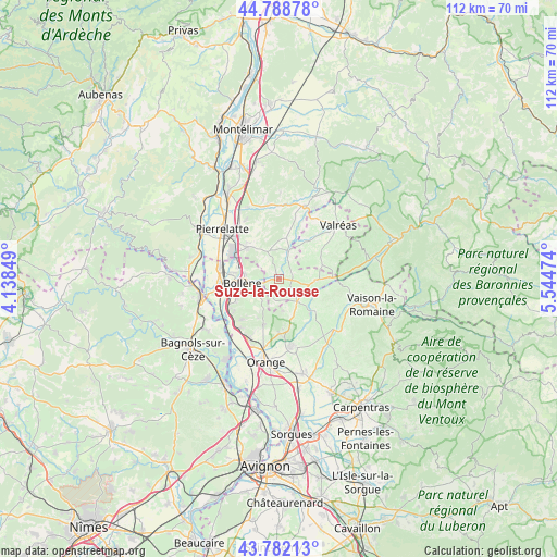
Suze-la-Rousse GPS coordinates[2]
44° 17' 15.396" North, 4° 50' 29.796" East
| Map corner | latitude | longitude |
|---|---|---|
| Upper-left | 44.78878°, | 4.13849° |
| Center: | 44.28761°, | 4.84161° |
| Lower-right: | 43.78213°, | 5.54474° |
| Map W x H: | 111.9×111.9 km | = 69.5×69.5mi |
| max Lat: | 51.07786° ⇑84.9% North |
| Suze-la-Rousse: | 44.28761° |
| min Lat: | ⇓15.1% South 41.3874° |
| min Long | Suze-la-Rousse | max Long |
| -5.08615° | 4.84161° | 9.52242° |
| W 75.7%⇐ | ⇒24.3% E |
Elevation
Elevation of Suze-la-Rousse is 100 m = 328 ft, and this is 93.7 m = 307 ft below average elevation for this country.
| Max E: |
2333 m = 7654 ft | 60.8% |
| Avg. | 193.7 m = 635 ft | |
| Suze-la-Rousse | 100 m = 328 ft | |
Min E: |
-1 m = -3 ft | 39.2% |
See also: France elevation on elevation.city.
Geographical zone
Suze-la-Rousse is located in North temperate zone (between Tropic of Cancer and the Arctic Circle). Distance of this Northern Tropic circle is 2318.4 km =1440.6 mi to South.| Distance of | km | miles | from Suze-la-Rousse |
|---|---|---|---|
| North Pole | 5082.7 | 3158.2 | to North |
| Arctic Circle | 2476.9 | 1539.1 | to North |
| Tropic Cancer | 2318.4 | 1440.6 | to South |
| Equator | 4924.3 | 3059.8 | to South |


Nearby cities:
15 places around Suze-la-Rousse: (largest is in red/bold)
• Bollène
7.4 km =4.6 mi,  264°
264°
• Bouchet
2.9 km =1.8 mi,  63°
63°
• Cairanne
9.5 km =5.9 mi,  129°
129°
• La Baume-de-Transit
5.8 km =3.6 mi,  19°
19°
• Mondragon
11.6 km =7.2 mi,  241°
241°
• Montségur-sur-Lauzon
8.2 km =5.1 mi,  7°
7°
• Richerenches
9.8 km =6.1 mi,  35°
35°
• Rochegude
5 km =3.1 mi,  193°
193°
• Saint-Paul-Trois-Châteaux
9 km =5.6 mi,  316°
316°
• Saint-Restitut
5.6 km =3.5 mi, 316°
• Sainte-Cécile-les-Vignes
5.9 km =3.7 mi,  142°
142°
• Sérignan-du-Comtat
10.9 km =6.8 mi,  179°
179°
• Tulette
7.1 km =4.4 mi,  90°
90°
• Uchaux
8.6 km =5.3 mi,  202°
202°
• Visan
9.2 km =5.7 mi,  70°
70°
Sources, notices
• [Note1] Compared only with cities in France existing in our database
• [Src1] Map data: © OpenStreetMap contributors (CC-BY-SA)
• [Src2] Other city data from geonames.org with taken over terms of usage.
• [Src3] Geographical zone / Annual Mean Temperature by Robert A. Rohde @ Wikipedia
