Pajay geodata
Pajay (Auvergne-Rhône-Alpes) is a populated place; located in France in Europe/Paris (GMT+2) time zone. With population of 866 people, there are 9930 cities with bigger population in this country. Compared to other cities in France, 75.7% of cities are located further ↑North; 79.1% of cities are located further ←West and 86% of cities have lower elevation than Pajay. Note1
Administrative division(s):
- Level 1: Auvergne-Rhône-Alpes
- Level 2: Département de l'Isère
- Level 3: Arrondissement de Vienne
- Level 4: Pajay


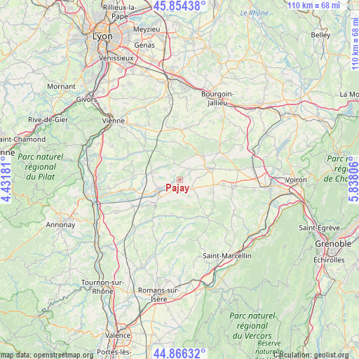
Pajay GPS coordinates[2]
45° 21' 45.036" North, 5° 8' 5.748" East
| Map corner | latitude | longitude |
|---|---|---|
| Upper-left | 45.85438°, | 4.43181° |
| Center: | 45.36251°, | 5.13493° |
| Lower-right: | 44.86632°, | 5.83806° |
| Map W x H: | 109.9×109.9 km | = 68.3×68.3mi |
| max Lat: | 51.07786° ⇑75.7% North |
| Pajay: | 45.36251° |
| min Lat: | ⇓24.3% South 41.3874° |
| min Long | Pajay | max Long |
| -5.08615° | 5.13493° | 9.52242° |
| W 79.1%⇐ | ⇒20.9% E |
Elevation
Elevation of Pajay is 360 m = 1181 ft, and this is 166.3 m = 546 ft above average elevation for this country.
| Max E: |
2333 m = 7654 ft | 14% |
| Pajay | 360 m 1181 ft | |
| Avg. | 193.7 m = 635 ft | |
Min E: |
-1 m = -3 ft | 86% |
See also: France elevation on elevation.city.
Geographical zone
Pajay is located in North temperate zone (between Tropic of Cancer and the Arctic Circle). Distance of this North polar circle is 2357.3 km =1464.8 mi to North.| Distance of | km | miles | from Pajay |
|---|---|---|---|
| North Pole | 4963.2 | 3084 | to North |
| Arctic Circle | 2357.3 | 1464.8 | to North |
| Tropic Cancer | 2437.9 | 1514.8 | to South |
| Equator | 5043.8 | 3134.1 | to South |


Nearby cities:
15 places around Pajay: (largest is in red/bold)
• Beaurepaire
7.3 km =4.5 mi,  246°
246°
• Commelle
10.2 km =6.3 mi,  44°
44°
• Faramans
4.1 km =2.5 mi, 35°
• La Côte-Saint-André
10.3 km =6.4 mi,  69°
69°
• Lens-Lestang
10.5 km =6.5 mi,  222°
222°
• Marcilloles
4.3 km =2.7 mi,  120°
120°
• Marcollin
7.6 km =4.7 mi,  213°
213°
• Pisieu
6.4 km =4 mi,  295°
295°
• Pommier-de-Beaurepaire
4.2 km =2.6 mi,  341°
341°
• Primarette
9.3 km =5.8 mi, 297°
• Revel
8.2 km =5.1 mi,  285°
285°
• Saint-Siméon-de-Bressieux
10.6 km =6.6 mi,  104°
104°
• Sardieu
6 km =3.7 mi,  83°
83°
• Thodure
5.7 km =3.5 mi,  152°
152°
• Viriville
7.5 km =4.7 mi,  133°
133°
Sources, notices
• [Note1] Compared only with cities in France existing in our database
• [Src1] Map data: © OpenStreetMap contributors (CC-BY-SA)
• [Src2] Other city data from geonames.org with taken over terms of usage.
• [Src3] Geographical zone / Annual Mean Temperature by Robert A. Rohde @ Wikipedia
