Ravenel geodata
Ravenel (Hauts-de-France) is a populated place; located in France in Europe/Paris (GMT+2) time zone. With population of 1,064 people, there are 8375 cities with bigger population in this country. Compared to other cities in France, 89.5% of cities are located further ↓South; 50.6% of cities are located further ←West and 56.5% of cities have higher elevation than Ravenel. Note1
Administrative division(s):
- Level 1: Hauts-de-France
- Level 2: Département de l'Oise
- Level 3: Arrondissement de Clermont
- Level 4: Ravenel


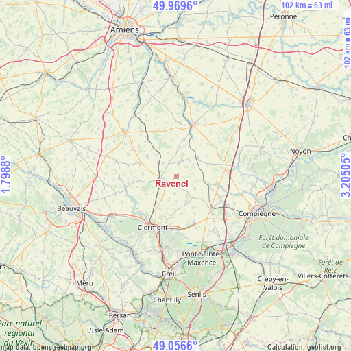
Ravenel GPS coordinates[2]
49° 30' 54.828" North, 2° 30' 6.912" East
| Map corner | latitude | longitude |
|---|---|---|
| Upper-left | 49.9696°, | 1.7988° |
| Center: | 49.51523°, | 2.50192° |
| Lower-right: | 49.0566°, | 3.20505° |
| Map W x H: | 101.5×101.5 km | = 63.1×63.1mi |
| max Lat: | 51.07786° ⇑10.5% North |
| Ravenel: | 49.51523° |
| min Lat: | ⇓89.5% South 41.3874° |
| min Long | Ravenel | max Long |
| -5.08615° | 2.50192° | 9.52242° |
| W 50.6%⇐ | ⇒49.4% E |
Elevation
Elevation of Ravenel is 112 m = 367 ft, and this is 81.7 m = 268 ft below average elevation for this country.
| Max E: |
2333 m = 7654 ft | 56.5% |
| Avg. | 193.7 m = 635 ft | |
| Ravenel | 112 m = 367 ft | |
Min E: |
-1 m = -3 ft | 43.5% |
See also: France elevation on elevation.city.
Geographical zone
Ravenel is located in North temperate zone (between Tropic of Cancer and the Arctic Circle). Distance of this North polar circle is 1895.6 km =1177.9 mi to North.| Distance of | km | miles | from Ravenel |
|---|---|---|---|
| North Pole | 4501.5 | 2797.1 | to North |
| Arctic Circle | 1895.6 | 1177.9 | to North |
| Tropic Cancer | 2899.7 | 1801.8 | to South |
| Equator | 5505.6 | 3421 | to South |


Nearby cities:
15 places around Ravenel: (largest is in red/bold)
• Airion
11.7 km =7.3 mi,  211°
211°
• Ansauvillers
10 km =6.2 mi,  303°
303°
• Avrechy
9.2 km =5.7 mi,  215°
215°
• Bailleul-le-Soc
12.2 km =7.6 mi,  153°
153°
• Catillon-Fumechon
9.8 km =6.1 mi,  270°
270°
• Erquery
12.3 km =7.6 mi,  195°
195°
• Fournival
10.1 km =6.3 mi,  237°
237°
• La Neuville-Roy
6.9 km =4.3 mi,  121°
121°
• Lieuvillers
5 km =3.1 mi,  183°
183°
• Maignelay-Montigny
4 km =2.5 mi,  15°
15°
• Moyenneville
10 km =6.2 mi,  106°
106°
• Méry-la-Bataille
9.8 km =6.1 mi,  69°
69°
• Saint-Just-en-Chaussée
5.1 km =3.2 mi,  257°
257°
• Tricot
8 km =5 mi,  50°
50°
• Wavignies
10.8 km =6.7 mi,  289°
289°
Sources, notices
• [Note1] Compared only with cities in France existing in our database
• [Src1] Map data: © OpenStreetMap contributors (CC-BY-SA)
• [Src2] Other city data from geonames.org with taken over terms of usage.
• [Src3] Geographical zone / Annual Mean Temperature by Robert A. Rohde @ Wikipedia
