Catillon-Fumechon geodata
Catillon-Fumechon (Hauts-de-France) is a populated place; located in France in Europe/Paris (GMT+2) time zone. With population of 541 people, there are 14367 cities with bigger population in this country. Compared to other cities in France, 89.5% of cities are located further ↓South; 51.5% of cities are located further →East and 55.6% of cities have lower elevation than Catillon-Fumechon. Note1
Administrative division(s):
- Level 1: Hauts-de-France
- Level 2: Département de l'Oise
- Level 3: Arrondissement de Clermont
- Level 4: Catillon-Fumechon


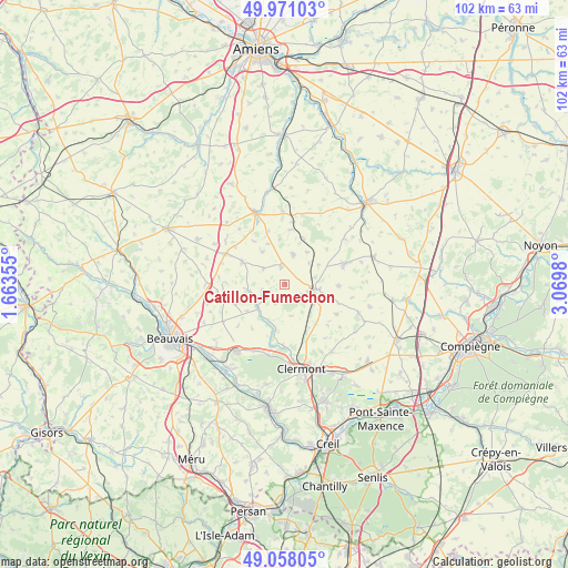
Catillon-Fumechon GPS coordinates[2]
49° 31' 0.012" North, 2° 22' 0.012" East
| Map corner | latitude | longitude |
|---|---|---|
| Upper-left | 49.97103°, | 1.66355° |
| Center: | 49.51667°, | 2.36667° |
| Lower-right: | 49.05805°, | 3.0698° |
| Map W x H: | 101.5×101.5 km | = 63.1×63.1mi |
| max Lat: | 51.07786° ⇑10.5% North |
| Catillon-Fumechon: | 49.51667° |
| min Lat: | ⇓89.5% South 41.3874° |
| min Long | Catillon-Fumech | max Long |
| -5.08615° | 2.36667° | 9.52242° |
| W 48.5%⇐ | ⇒51.5% E |
Elevation
Elevation of Catillon-Fumechon is 152 m = 499 ft, and this is 41.7 m = 137 ft below average elevation for this country.
| Max E: |
2333 m = 7654 ft | 44.4% |
| Avg. | 193.7 m = 635 ft | |
| Catillon-Fumechon | 152 m = 499 ft | |
Min E: |
-1 m = -3 ft | 55.6% |
See also: France elevation on elevation.city.
Geographical zone
Catillon-Fumechon is located in North temperate zone (between Tropic of Cancer and the Arctic Circle). Distance of this North polar circle is 1895.4 km =1177.7 mi to North.| Distance of | km | miles | from Catillon-Fumechon |
|---|---|---|---|
| North Pole | 4501.3 | 2797 | to North |
| Arctic Circle | 1895.4 | 1177.7 | to North |
| Tropic Cancer | 2899.8 | 1801.9 | to South |
| Equator | 5505.7 | 3421.1 | to South |


Nearby cities:
15 places around Catillon-Fumechon: (largest is in red/bold)
• Airion
10.8 km =6.7 mi,  160°
160°
• Ansauvillers
5.6 km =3.5 mi,  15°
15°
• Avrechy
8.8 km =5.5 mi,  150°
150°
• Bulles
7 km =4.3 mi,  204°
204°
• Fournival
5.7 km =3.5 mi,  167°
167°
• Froissy
11.9 km =7.4 mi,  298°
298°
• Haudivillers
9.5 km =5.9 mi,  250°
250°
• Lieuvillers
10.8 km =6.7 mi,  118°
118°
• Maignelay-Montigny
11.4 km =7.1 mi,  71°
71°
• Noyers-Saint-Martin
8.6 km =5.3 mi, 298°
• Ravenel
9.8 km =6.1 mi,  90°
90°
• Saint-André-Farivillers
9.5 km =5.9 mi,  325°
325°
• Saint-Just-en-Chaussée
5 km =3.1 mi,  105°
105°
• Wavignies
3.5 km =2.2 mi,  352°
352°
• Étouy
10.9 km =6.8 mi,  181°
181°
Sources, notices
• [Note1] Compared only with cities in France existing in our database
• [Src1] Map data: © OpenStreetMap contributors (CC-BY-SA)
• [Src2] Other city data from geonames.org with taken over terms of usage.
• [Src3] Geographical zone / Annual Mean Temperature by Robert A. Rohde @ Wikipedia
