Carignan-de-Bordeaux geodata
Carignan-de-Bordeaux (Nouvelle-Aquitaine) is a populated place; located in France in Europe/Paris (GMT+2) time zone. With population of 3,343 people, there are 2920 cities with bigger population in this country. Compared to other cities in France, 81.4% of cities are located further ↑North; 83.2% of cities are located further →East and 77% of cities have higher elevation than Carignan-de-Bordeaux. Note1
Administrative division(s):
- Level 1: Nouvelle-Aquitaine
- Level 2: Gironde
- Level 3: Arrondissement de Bordeaux
- Level 4: Carignan-de-Bordeaux


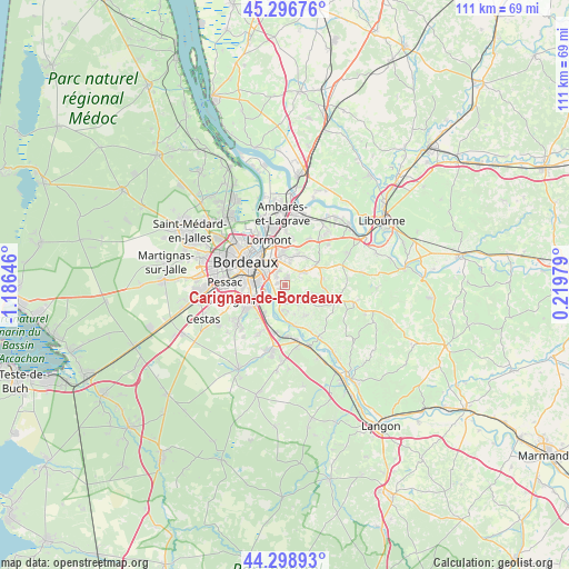
Carignan-de-Bordeaux GPS coordinates[2]
44° 48' 0" North, 0° 28' 59.988" West
| Map corner | latitude | longitude |
|---|---|---|
| Upper-left | 45.29676°, | -1.18646° |
| Center: | 44.8°, | -0.48333° |
| Lower-right: | 44.29893°, | 0.21979° |
| Map W x H: | 110.9×110.9 km | = 68.9×68.9mi |
| max Lat: | 51.07786° ⇑81.4% North |
| Carignan-de-Bordeaux: | 44.8° |
| min Lat: | ⇓18.6% South 41.3874° |
| min Long | Carignan-de-Bor | max Long |
| -5.08615° | -0.48333° | 9.52242° |
| W 16.8%⇐ | ⇒83.2% E |
Elevation
Elevation of Carignan-de-Bordeaux is 62 m = 203 ft, and this is 131.7 m = 432 ft below average elevation for this country.
| Max E: |
2333 m = 7654 ft | 77% |
| Avg. | 193.7 m = 635 ft | |
| Carignan-de-Bordeaux | 62 m = 203 ft | |
Min E: |
-1 m = -3 ft | 23% |
See also: France elevation on elevation.city.
Geographical zone
Carignan-de-Bordeaux is located in North temperate zone (between Tropic of Cancer and the Arctic Circle). Distance of this Northern Tropic circle is 2375.4 km =1476 mi to South.| Distance of | km | miles | from Carignan-de-Bordeaux |
|---|---|---|---|
| North Pole | 5025.8 | 3122.9 | to North |
| Arctic Circle | 2419.9 | 1503.7 | to North |
| Tropic Cancer | 2375.4 | 1476 | to South |
| Equator | 4981.3 | 3095.2 | to South |


Nearby cities:
15 places around Carignan-de-Bordeaux: (largest is in red/bold)
• Artigues-près-Bordeaux
6.1 km =3.8 mi,  334°
334°
• Bonnetan
5.6 km =3.5 mi,  72°
72°
• Bouliac
2.4 km =1.5 mi,  321°
321°
• Bègles
5.2 km =3.2 mi,  280°
280°
• Cadaujac
6.3 km =3.9 mi,  216°
216°
• Camblanes-et-Meynac
3.8 km =2.4 mi,  183°
183°
• Cénac
2.9 km =1.8 mi,  140°
140°
• Fargues-Saint-Hilaire
3.9 km =2.4 mi,  48°
48°
• Floirac
4.3 km =2.7 mi, 326°
• Latresne
1.6 km =1 mi,  198°
198°
• Lignan-de-Bordeaux
4.4 km =2.7 mi,  94°
94°
• Quinsac
5 km =3.1 mi, 183°
• Sadirac
5.9 km =3.7 mi,  110°
110°
• Tresses
5.6 km =3.5 mi,  16°
16°
• Villenave-d’Ornon
5.6 km =3.5 mi,  238°
238°
Sources, notices
• [Note1] Compared only with cities in France existing in our database
• [Src1] Map data: © OpenStreetMap contributors (CC-BY-SA)
• [Src2] Other city data from geonames.org with taken over terms of usage.
• [Src3] Geographical zone / Annual Mean Temperature by Robert A. Rohde @ Wikipedia
