Pujo-le-Plan geodata
Pujo-le-Plan (Nouvelle-Aquitaine) is a populated place; located in France in Europe/Paris (GMT+2) time zone. With population of 592 people, there are 13451 cities with bigger population in this country. Compared to other cities in France, 88.5% of cities are located further ↑North; 81.2% of cities are located further →East and 73.6% of cities have higher elevation than Pujo-le-Plan. Note1
Administrative division(s):
- Level 1: Nouvelle-Aquitaine
- Level 2: Landes
- Level 3: Arrondissement de Mont-de-Marsan
- Level 4: Pujo-le-Plan


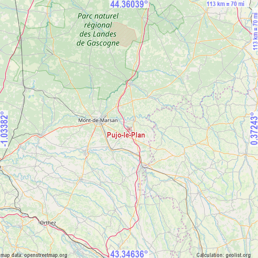
Pujo-le-Plan GPS coordinates[2]
43° 51' 19.908" North, 0° 19' 50.484" West
| Map corner | latitude | longitude |
|---|---|---|
| Upper-left | 44.36039°, | -1.03382° |
| Center: | 43.85553°, | -0.33069° |
| Lower-right: | 43.34636°, | 0.37243° |
| Map W x H: | 112.7×112.7 km | = 70×70mi |
| max Lat: | 51.07786° ⇑88.5% North |
| Pujo-le-Plan: | 43.85553° |
| min Lat: | ⇓11.5% South 41.3874° |
| min Long | Pujo-le-Plan | max Long |
| -5.08615° | -0.33069° | 9.52242° |
| W 18.8%⇐ | ⇒81.2% E |
Elevation
Elevation of Pujo-le-Plan is 70 m = 230 ft, and this is 123.7 m = 406 ft below average elevation for this country.
| Max E: |
2333 m = 7654 ft | 73.6% |
| Avg. | 193.7 m = 635 ft | |
| Pujo-le-Plan | 70 m = 230 ft | |
Min E: |
-1 m = -3 ft | 26.4% |
See also: France elevation on elevation.city.
Geographical zone
Pujo-le-Plan is located in North temperate zone (between Tropic of Cancer and the Arctic Circle). Distance of this Northern Tropic circle is 2270.4 km =1410.8 mi to South.| Distance of | km | miles | from Pujo-le-Plan |
|---|---|---|---|
| North Pole | 5130.8 | 3188.1 | to North |
| Arctic Circle | 2524.9 | 1568.9 | to North |
| Tropic Cancer | 2270.4 | 1410.8 | to South |
| Equator | 4876.3 | 3030 | to South |


Nearby cities:
15 places around Pujo-le-Plan: (largest is in red/bold)
• Bascons
7.9 km =4.9 mi,  242°
242°
• Benquet
14 km =8.7 mi,  258°
258°
• Bougue
6.2 km =3.9 mi,  307°
307°
• Bretagne-de-Marsan
10.8 km =6.7 mi,  265°
265°
• Cazères-sur-l’Adour
10.5 km =6.5 mi,  173°
173°
• Grenade-sur-l’Adour
11.8 km =7.3 mi,  222°
222°
• Hontanx
5.7 km =3.5 mi,  126°
126°
• Laglorieuse
6.1 km =3.8 mi,  284°
284°
• Larrivière-Saint-Savin
12.1 km =7.5 mi,  214°
214°
• Mont-de-Marsan
13.9 km =8.6 mi,  286°
286°
• Pouydesseaux
12.6 km =7.8 mi,  2°
2°
• Renung
12.2 km =7.6 mi,  189°
189°
• Saint-Avit
13.3 km =8.3 mi,  315°
315°
• Saint-Maurice-sur-Adour
13.4 km =8.3 mi,  234°
234°
• Villeneuve-de-Marsan
4.1 km =2.5 mi,  24°
24°
Sources, notices
• [Note1] Compared only with cities in France existing in our database
• [Src1] Map data: © OpenStreetMap contributors (CC-BY-SA)
• [Src2] Other city data from geonames.org with taken over terms of usage.
• [Src3] Geographical zone / Annual Mean Temperature by Robert A. Rohde @ Wikipedia
