Laglorieuse geodata
Laglorieuse (Nouvelle-Aquitaine) is a populated place; located in France in Europe/Paris (GMT+2) time zone. With population of 623 people, there are 12932 cities with bigger population in this country. Compared to other cities in France, 88.4% of cities are located further ↑North; 82.2% of cities are located further →East and 71% of cities have higher elevation than Laglorieuse. Note1
Administrative division(s):
- Level 1: Nouvelle-Aquitaine
- Level 2: Landes
- Level 3: Arrondissement de Mont-de-Marsan
- Level 4: Laglorieuse


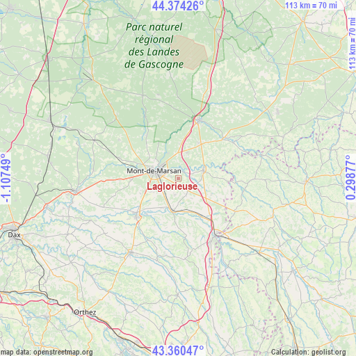
Laglorieuse GPS coordinates[2]
43° 52' 10.272" North, 0° 24' 15.696" West
| Map corner | latitude | longitude |
|---|---|---|
| Upper-left | 44.37426°, | -1.10749° |
| Center: | 43.86952°, | -0.40436° |
| Lower-right: | 43.36047°, | 0.29877° |
| Map W x H: | 112.7×112.7 km | = 70×70mi |
| max Lat: | 51.07786° ⇑88.4% North |
| Laglorieuse: | 43.86952° |
| min Lat: | ⇓11.6% South 41.3874° |
| min Long | Laglorieuse | max Long |
| -5.08615° | -0.40436° | 9.52242° |
| W 17.8%⇐ | ⇒82.2% E |
Elevation
Elevation of Laglorieuse is 76 m = 249 ft, and this is 117.7 m = 386 ft below average elevation for this country.
| Max E: |
2333 m = 7654 ft | 71% |
| Avg. | 193.7 m = 635 ft | |
| Laglorieuse | 76 m = 249 ft | |
Min E: |
-1 m = -3 ft | 29% |
See also: France elevation on elevation.city.
Geographical zone
Laglorieuse is located in North temperate zone (between Tropic of Cancer and the Arctic Circle). Distance of this Northern Tropic circle is 2271.9 km =1411.7 mi to South.| Distance of | km | miles | from Laglorieuse |
|---|---|---|---|
| North Pole | 5129.2 | 3187.1 | to North |
| Arctic Circle | 2523.3 | 1567.9 | to North |
| Tropic Cancer | 2271.9 | 1411.7 | to South |
| Equator | 4877.8 | 3030.9 | to South |


Nearby cities:
15 places around Laglorieuse: (largest is in red/bold)
• Bascons
5.3 km =3.3 mi,  191°
191°
• Benquet
8.9 km =5.5 mi,  240°
240°
• Bougue
2.5 km =1.6 mi,  23°
23°
• Bretagne-de-Marsan
5.4 km =3.4 mi, 243°
• Grenade-sur-l’Adour
10.4 km =6.5 mi, 191°
• Haut-Mauco
13 km =8.1 mi,  248°
248°
• Hontanx
11.6 km =7.2 mi,  115°
115°
• Larrivière-Saint-Savin
11.5 km =7.1 mi,  184°
184°
• Mont-de-Marsan
7.8 km =4.8 mi,  287°
287°
• Pouydesseaux
12.8 km =8 mi,  30°
30°
• Pujo-le-Plan
6.1 km =3.8 mi,  104°
104°
• Saint-Avit
8.6 km =5.3 mi,  336°
336°
• Saint-Maurice-sur-Adour
10.6 km =6.6 mi,  208°
208°
• Saint-Pierre-du-Mont
9.6 km =6 mi,  280°
280°
• Villeneuve-de-Marsan
7.9 km =4.9 mi,  74°
74°
Sources, notices
• [Note1] Compared only with cities in France existing in our database
• [Src1] Map data: © OpenStreetMap contributors (CC-BY-SA)
• [Src2] Other city data from geonames.org with taken over terms of usage.
• [Src3] Geographical zone / Annual Mean Temperature by Robert A. Rohde @ Wikipedia
