Mont-de-Marsan geodata
Mont-de-Marsan (Nouvelle-Aquitaine) is a seat of a second-order administrative division; located in France in Europe/Paris (GMT+2) time zone. With population of 36,205 people, there are 211 cities with bigger population in this country. Compared to other cities in France, 88.2% of cities are located further ↑North; 83.3% of cities are located further →East and 81.5% of cities have higher elevation than Mont-de-Marsan. Note1
Administrative division(s):
- Level 1: Nouvelle-Aquitaine
- Level 2: Landes
- Level 3: Arrondissement de Mont-de-Marsan
- Level 4: Mont-de-Marsan


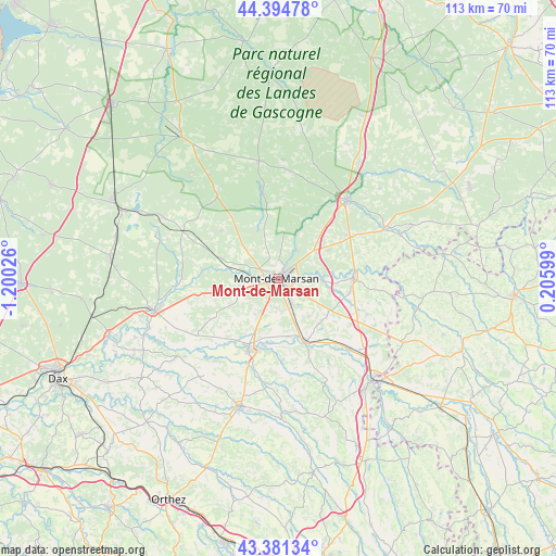
Mont-de-Marsan GPS coordinates[2]
43° 53' 24.792" North, 0° 29' 49.668" West
| Map corner | latitude | longitude |
|---|---|---|
| Upper-left | 44.39478°, | -1.20026° |
| Center: | 43.89022°, | -0.49713° |
| Lower-right: | 43.38134°, | 0.20599° |
| Map W x H: | 112.7×112.7 km | = 70×70mi |
| max Lat: | 51.07786° ⇑88.2% North |
| Mont-de-Marsan: | 43.89022° |
| min Lat: | ⇓11.8% South 41.3874° |
| min Long | Mont-de-Marsan | max Long |
| -5.08615° | -0.49713° | 9.52242° |
| W 16.7%⇐ | ⇒83.3% E |
Elevation
Elevation of Mont-de-Marsan is 51 m = 167 ft, and this is 142.7 m = 468 ft below average elevation for this country.
| Max E: |
2333 m = 7654 ft | 81.5% |
| Avg. | 193.7 m = 635 ft | |
| Mont-de-Marsan | 51 m = 167 ft | |
Min E: |
-1 m = -3 ft | 18.5% |
See also: France elevation on elevation.city.
Geographical zone
Mont-de-Marsan is located in North temperate zone (between Tropic of Cancer and the Arctic Circle). Distance of this Northern Tropic circle is 2274.2 km =1413.1 mi to South.| Distance of | km | miles | from Mont-de-Marsan |
|---|---|---|---|
| North Pole | 5126.9 | 3185.7 | to North |
| Arctic Circle | 2521 | 1566.5 | to North |
| Tropic Cancer | 2274.2 | 1413.1 | to South |
| Equator | 4880.1 | 3032.4 | to South |


Nearby cities:
15 places around Mont-de-Marsan: (largest is in red/bold)
• Aurice
12 km =7.5 mi,  225°
225°
• Bascons
9.9 km =6.2 mi,  139°
139°
• Benquet
6.7 km =4.2 mi,  182°
182°
• Bougue
8.4 km =5.2 mi,  90°
90°
• Bretagne-de-Marsan
5.4 km =3.4 mi,  151°
151°
• Campagne
11.7 km =7.3 mi,  256°
256°
• Grenade-sur-l’Adour
13.7 km =8.5 mi,  156°
156°
• Haut-Mauco
8.4 km =5.2 mi,  213°
213°
• Laglorieuse
7.8 km =4.8 mi,  107°
107°
• Pujo-le-Plan
13.9 km =8.6 mi, 106°
• Saint-Avit
6.9 km =4.3 mi,  35°
35°
• Saint-Maurice-sur-Adour
11.9 km =7.4 mi,  168°
168°
• Saint-Perdon
8 km =5 mi,  249°
249°
• Saint-Pierre-du-Mont
2.1 km =1.3 mi, 252°
• Uchacq-et-Parentis
6.5 km =4 mi,  309°
309°
Sources, notices
• [Note1] Compared only with cities in France existing in our database
• [Src1] Map data: © OpenStreetMap contributors (CC-BY-SA)
• [Src2] Other city data from geonames.org with taken over terms of usage.
• [Src3] Geographical zone / Annual Mean Temperature by Robert A. Rohde @ Wikipedia
