Larrivière-Saint-Savin geodata
Larrivière-Saint-Savin (Nouvelle-Aquitaine) is a populated place; located in France in Europe/Paris (GMT+2) time zone. With population of 628 people, there are 12854 cities with bigger population in this country. Compared to other cities in France, 89.5% of cities are located further ↑North; 82.4% of cities are located further →East and 77.8% of cities have higher elevation than Larrivière-Saint-Savin. Note1
Administrative division(s):
- Level 1: Nouvelle-Aquitaine
- Level 2: Landes
- Level 3: Arrondissement de Mont-de-Marsan
- Level 4: Larrivière-Saint-Savin
Current local time in Larrivière-Saint-Savin:
05:58 AM, WednesdayDifference from your time zone: hours


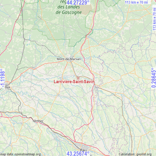
Larrivière-Saint-Savin GPS coordinates[2]
43° 46' 0.012" North, 0° 25' 0.012" West
| Map corner | latitude | longitude |
|---|---|---|
| Upper-left | 44.27229°, | -1.1198° |
| Center: | 43.76667°, | -0.41667° |
| Lower-right: | 43.25674°, | 0.28645° |
| Map W x H: | 112.9×112.9 km | = 70.2×70.2mi |
| max Lat: | 51.07786° ⇑89.5% North |
| Larrivière-Saint-Savin: | 43.76667° |
| min Lat: | ⇓10.5% South 41.3874° |
| min Long | Larrivière-Sai | max Long |
| -5.08615° | -0.41667° | 9.52242° |
| W 17.6%⇐ | ⇒82.4% E |
Elevation
Elevation of Larrivière-Saint-Savin is 60 m = 197 ft, and this is 133.7 m = 439 ft below average elevation for this country.
| Max E: |
2333 m = 7654 ft | 77.8% |
| Avg. | 193.7 m = 635 ft | |
| Larrivière-Saint-Savin | 60 m = 197 ft | |
Min E: |
-1 m = -3 ft | 22.2% |
See also: France elevation on elevation.city.
Geographical zone
Larrivière-Saint-Savin is located in North temperate zone (between Tropic of Cancer and the Arctic Circle). Distance of this Northern Tropic circle is 2260.5 km =1404.6 mi to South.| Distance of | km | miles | from Larrivière-Saint-Savin |
|---|---|---|---|
| North Pole | 5140.7 | 3194.3 | to North |
| Arctic Circle | 2534.8 | 1575.1 | to North |
| Tropic Cancer | 2260.5 | 1404.6 | to South |
| Equator | 4866.4 | 3023.8 | to South |


Nearby cities:
15 places around Larrivière-Saint-Savin: (largest is in red/bold)
• Bascons
6.2 km =3.9 mi,  359°
359°
• Benquet
9.8 km =6.1 mi,  316°
316°
• Bretagne-de-Marsan
9.8 km =6.1 mi,  336°
336°
• Cazères-sur-l’Adour
8.1 km =5 mi,  94°
94°
• Duhort-Bachen
8.9 km =5.5 mi,  122°
122°
• Eugénie-les-Bains
8.4 km =5.2 mi,  158°
158°
• Grenade-sur-l’Adour
1.6 km =1 mi, 319°
• Haut-Mauco
13 km =8.1 mi,  301°
301°
• Laglorieuse
11.5 km =7.1 mi,  4°
4°
• Montgaillard
6 km =3.7 mi,  243°
243°
• Montsoué
8.2 km =5.1 mi, 242°
• Pujo-le-Plan
12.1 km =7.5 mi,  34°
34°
• Renung
5.4 km =3.4 mi,  113°
113°
• Saint-Maurice-sur-Adour
4.5 km =2.8 mi, 297°
• Saint-Sever
12.6 km =7.8 mi,  265°
265°
Sources, notices
• [Note1] Compared only with cities in France existing in our database
• [Src1] Map data: © OpenStreetMap contributors (CC-BY-SA)
• [Src2] Other city data from geonames.org with taken over terms of usage.
• [Src3] Geographical zone / Annual Mean Temperature by Robert A. Rohde @ Wikipedia
