Renung geodata
Renung (Nouvelle-Aquitaine) is a populated place; located in France in Europe/Paris (GMT+2) time zone. With population of 506 people, there are 15128 cities with bigger population in this country. Compared to other cities in France, 89.8% of cities are located further ↑North; 81.5% of cities are located further →East and 50.9% of cities have higher elevation than Renung. Note1
Administrative division(s):
- Level 1: Nouvelle-Aquitaine
- Level 2: Landes
- Level 3: Arrondissement de Mont-de-Marsan
- Level 4: Renung


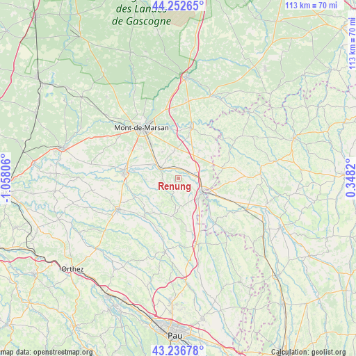
Renung GPS coordinates[2]
43° 44' 48.732" North, 0° 21' 17.748" West
| Map corner | latitude | longitude |
|---|---|---|
| Upper-left | 44.25265°, | -1.05806° |
| Center: | 43.74687°, | -0.35493° |
| Lower-right: | 43.23678°, | 0.3482° |
| Map W x H: | 113×113 km | = 70.2×70.2mi |
| max Lat: | 51.07786° ⇑89.8% North |
| Renung: | 43.74687° |
| min Lat: | ⇓10.2% South 41.3874° |
| min Long | Renung | max Long |
| -5.08615° | -0.35493° | 9.52242° |
| W 18.5%⇐ | ⇒81.5% E |
Elevation
Elevation of Renung is 129 m = 423 ft, and this is 64.7 m = 212 ft below average elevation for this country.
| Max E: |
2333 m = 7654 ft | 50.9% |
| Avg. | 193.7 m = 635 ft | |
| Renung | 129 m = 423 ft | |
Min E: |
-1 m = -3 ft | 49.1% |
See also: France elevation on elevation.city.
Geographical zone
Renung is located in North temperate zone (between Tropic of Cancer and the Arctic Circle). Distance of this Northern Tropic circle is 2258.3 km =1403.2 mi to South.| Distance of | km | miles | from Renung |
|---|---|---|---|
| North Pole | 5142.9 | 3195.6 | to North |
| Arctic Circle | 2537 | 1576.4 | to North |
| Tropic Cancer | 2258.3 | 1403.2 | to South |
| Equator | 4864.2 | 3022.5 | to South |


Nearby cities:
15 places around Renung: (largest is in red/bold)
• Barcelonne-du-Gers
10.7 km =6.6 mi,  116°
116°
• Bascons
9.8 km =6.1 mi,  329°
329°
• Bretagne-de-Marsan
14.2 km =8.8 mi,  321°
321°
• Cazères-sur-l’Adour
3.6 km =2.2 mi,  62°
62°
• Duhort-Bachen
3.6 km =2.2 mi,  134°
134°
• Eugénie-les-Bains
5.9 km =3.7 mi,  198°
198°
• Geaune
11.9 km =7.4 mi,  189°
189°
• Grenade-sur-l’Adour
6.9 km =4.3 mi,  299°
299°
• Hontanx
10.9 km =6.8 mi,  37°
37°
• Laglorieuse
14.2 km =8.8 mi,  343°
343°
• Larrivière-Saint-Savin
5.4 km =3.4 mi,  293°
293°
• Montgaillard
10.3 km =6.4 mi,  267°
267°
• Montsoué
12.4 km =7.7 mi,  262°
262°
• Pujo-le-Plan
12.2 km =7.6 mi,  9°
9°
• Saint-Maurice-sur-Adour
10 km =6.2 mi, 295°
Sources, notices
• [Note1] Compared only with cities in France existing in our database
• [Src1] Map data: © OpenStreetMap contributors (CC-BY-SA)
• [Src2] Other city data from geonames.org with taken over terms of usage.
• [Src3] Geographical zone / Annual Mean Temperature by Robert A. Rohde @ Wikipedia
