Los Masos geodata
Los Masos (Occitanie) is a populated place; located in France in Europe/Paris (GMT+2) time zone. With population of 646 people, there are 12578 cities with bigger population in this country. Compared to other cities in France, 99.2% of cities are located further ↑North; 50.2% of cities are located further →East and 81.5% of cities have lower elevation than Los Masos. Note1
Administrative division(s):
- Level 1: Occitanie
- Level 2: Département des Pyrénées-Orientales
- Level 3: Arrondissement de Prades
- Level 4: Los Masos


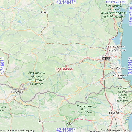
Los Masos GPS coordinates[2]
42° 37' 59.988" North, 2° 27' 0" East
| Map corner | latitude | longitude |
|---|---|---|
| Upper-left | 43.14847°, | 1.74687° |
| Center: | 42.63333°, | 2.45° |
| Lower-right: | 42.11389°, | 3.15312° |
| Map W x H: | 115×115 km | = 71.5×71.5mi |
| max Lat: | 51.07786° ⇑99.2% North |
| Los Masos: | 42.63333° |
| min Lat: | ⇓0.8% South 41.3874° |
| min Long | Los Masos | max Long |
| -5.08615° | 2.45° | 9.52242° |
| W 49.8%⇐ | ⇒50.2% E |
Elevation
Elevation of Los Masos is 305 m = 1001 ft, and this is 111.3 m = 365 ft above average elevation for this country.
| Max E: |
2333 m = 7654 ft | 18.5% |
| Los Masos | 305 m 1001 ft | |
| Avg. | 193.7 m = 635 ft | |
Min E: |
-1 m = -3 ft | 81.5% |
See also: France elevation on elevation.city.
Geographical zone
Los Masos is located in North temperate zone (between Tropic of Cancer and the Arctic Circle). Distance of this Northern Tropic circle is 2134.5 km =1326.3 mi to South.| Distance of | km | miles | from Los Masos |
|---|---|---|---|
| North Pole | 5266.7 | 3272.6 | to North |
| Arctic Circle | 2660.8 | 1653.3 | to North |
| Tropic Cancer | 2134.5 | 1326.3 | to South |
| Equator | 4740.4 | 2945.5 | to South |


Nearby cities:
15 places around Los Masos: (largest is in red/bold)
• Bouleternère
11.2 km =7 mi,  80°
80°
• Catllar
2.3 km =1.4 mi,  270°
270°
• Caudiès-de-Fenouillèdes
20.8 km =12.9 mi,  342°
342°
• Corbère
17.4 km =10.8 mi, 82°
• Corbère-les-Cabanes
18.6 km =11.6 mi, 81°
• Ille-sur-Têt
14.6 km =9.1 mi,  73°
73°
• Marquixanes
2.9 km =1.8 mi, 73°
• Millas
21.1 km =13.1 mi, 71°
• Néfiach
19 km =11.8 mi, 69°
• Prades
2.9 km =1.8 mi,  231°
231°
• Ria-Sirach
4.5 km =2.8 mi,  245°
245°
• Rodès
9.5 km =5.9 mi, 74°
• Saint-Paul-de-Fenouillet
20.1 km =12.5 mi,  12°
12°
• Vernet-les-Bains
10.8 km =6.7 mi,  208°
208°
• Vinça
6.5 km =4 mi, 78°
Sources, notices
• [Note1] Compared only with cities in France existing in our database
• [Src1] Map data: © OpenStreetMap contributors (CC-BY-SA)
• [Src2] Other city data from geonames.org with taken over terms of usage.
• [Src3] Geographical zone / Annual Mean Temperature by Robert A. Rohde @ Wikipedia
