Portvendres geodata
Portvendres (Occitanie) is a populated place; located in France in Europe/Paris (GMT+2) time zone. With population of 4,479 people, there are 2202 cities with bigger population in this country. Compared to other cities in France, 99.5% of cities are located further ↑North; 59.4% of cities are located further ←West and 98.6% of cities have higher elevation than Portvendres. Note1
Administrative division(s):
- Level 1: Occitanie
- Level 2: Département des Pyrénées-Orientales
- Level 3: Arrondissement de Céret
- Level 4: Port-Vendres


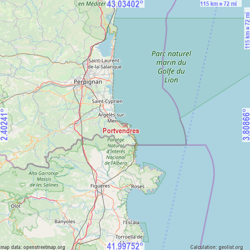
Portvendres GPS coordinates[2]
42° 31' 4.512" North, 3° 6' 19.908" East
| Map corner | latitude | longitude |
|---|---|---|
| Upper-left | 43.03402°, | 2.40241° |
| Center: | 42.51792°, | 3.10553° |
| Lower-right: | 41.99752°, | 3.80866° |
| Map W x H: | 115.2×115.2 km | = 71.6×71.6mi |
| max Lat: | 51.07786° ⇑99.5% North |
| Portvendres: | 42.51792° |
| min Lat: | ⇓0.5% South 41.3874° |
| min Long | Portvendres | max Long |
| -5.08615° | 3.10553° | 9.52242° |
| W 59.4%⇐ | ⇒40.6% E |
Elevation
Elevation of Portvendres is 7 m = 23 ft, and this is 186.7 m = 613 ft below average elevation for this country.
| Max E: |
2333 m = 7654 ft | 98.6% |
| Avg. | 193.7 m = 635 ft | |
| Portvendres | 7 m = 23 ft | |
Min E: |
-1 m = -3 ft | 1.4% |
See also: France elevation on elevation.city.
Geographical zone
Portvendres is located in North temperate zone (between Tropic of Cancer and the Arctic Circle). Distance of this Northern Tropic circle is 2121.6 km =1318.3 mi to South.| Distance of | km | miles | from Portvendres |
|---|---|---|---|
| North Pole | 5279.5 | 3280.5 | to North |
| Arctic Circle | 2673.6 | 1661.3 | to North |
| Tropic Cancer | 2121.6 | 1318.3 | to South |
| Equator | 4727.5 | 2937.5 | to South |


Nearby cities:
15 places around Portvendres: (largest is in red/bold)
• Alénya
16.8 km =10.4 mi,  322°
322°
• Argelers
7.5 km =4.7 mi,  295°
295°
• Banyuls de la Marenda
4.3 km =2.7 mi,  153°
153°
• Cervera de la Marenda
9.9 km =6.2 mi, 150°
• Collioure
2 km =1.2 mi,  291°
291°
• Elne
14.3 km =8.9 mi,  309°
309°
• Latour-Bas-Elne
13 km =8.1 mi, 319°
• Ortaffa
16.2 km =10.1 mi, 295°
• Palau-del-Vidre
13.3 km =8.3 mi, 296°
• Saint-Cyprien-Plage
14 km =8.7 mi,  335°
335°
• Saint-Génis-des-Fontaines
15.4 km =9.6 mi,  280°
280°
• Sant Andreu de Sureda
11.6 km =7.2 mi, 289°
• Sorède
12.2 km =7.6 mi, 276°
• Vilallonga dels Monts
16.5 km =10.3 mi,  272°
272°
• la Roca d'Albera
14.1 km =8.8 mi, 271°
Sources, notices
• [Note1] Compared only with cities in France existing in our database
• [Src1] Map data: © OpenStreetMap contributors (CC-BY-SA)
• [Src2] Other city data from geonames.org with taken over terms of usage.
• [Src3] Geographical zone / Annual Mean Temperature by Robert A. Rohde @ Wikipedia
