Argelers geodata
Argelers (Occitanie) is a populated place; located in France in Europe/Paris (GMT+2) time zone. With population of 10,044 people, there are 949 cities with bigger population in this country. Compared to other cities in France, 99.4% of cities are located further ↑North; 58.2% of cities are located further ←West and 93.9% of cities have higher elevation than Argelers. Note1
Administrative division(s):
- Level 1: Occitanie
- Level 2: Département des Pyrénées-Orientales
- Level 3: Arrondissement de Céret
- Level 4: Argelès-sur-Mer


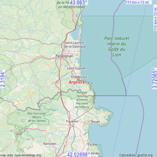
Argelers GPS coordinates[2]
42° 32' 49.704" North, 3° 1' 21.108" East
| Map corner | latitude | longitude |
|---|---|---|
| Upper-left | 43.063°, | 2.3194° |
| Center: | 42.54714°, | 3.02253° |
| Lower-right: | 42.02698°, | 3.72565° |
| Map W x H: | 115.2×115.2 km | = 71.6×71.6mi |
| max Lat: | 51.07786° ⇑99.4% North |
| Argelers: | 42.54714° |
| min Lat: | ⇓0.6% South 41.3874° |
| min Long | Argelers | max Long |
| -5.08615° | 3.02253° | 9.52242° |
| W 58.2%⇐ | ⇒41.8% E |
Elevation
Elevation of Argelers is 20 m = 66 ft, and this is 173.7 m = 570 ft below average elevation for this country.
| Max E: |
2333 m = 7654 ft | 93.9% |
| Avg. | 193.7 m = 635 ft | |
| Argelers | 20 m = 66 ft | |
Min E: |
-1 m = -3 ft | 6.1% |
See also: France elevation on elevation.city.
Geographical zone
Argelers is located in North temperate zone (between Tropic of Cancer and the Arctic Circle). Distance of this Northern Tropic circle is 2124.9 km =1320.4 mi to South.| Distance of | km | miles | from Argelers |
|---|---|---|---|
| North Pole | 5276.3 | 3278.5 | to North |
| Arctic Circle | 2670.4 | 1659.3 | to North |
| Tropic Cancer | 2124.9 | 1320.4 | to South |
| Equator | 4730.8 | 2939.6 | to South |


Nearby cities:
15 places around Argelers: (largest is in red/bold)
• Brouilla
10 km =6.2 mi,  282°
282°
• Collioure
5.5 km =3.4 mi,  117°
117°
• Corneilla-del-Vercol
10.3 km =6.4 mi,  325°
325°
• Elne
7.2 km =4.5 mi,  324°
324°
• Latour-Bas-Elne
6.8 km =4.2 mi,  345°
345°
• Montescot
9.9 km =6.2 mi,  312°
312°
• Ortaffa
8.7 km =5.4 mi,  294°
294°
• Palau-del-Vidre
5.8 km =3.6 mi,  298°
298°
• Portvendres
7.5 km =4.7 mi, 115°
• Saint-Cyprien-Plage
9.5 km =5.9 mi,  5°
5°
• Saint-Génis-des-Fontaines
8.4 km =5.2 mi,  267°
267°
• Sant Andreu de Sureda
4.2 km =2.6 mi, 277°
• Sorède
5.7 km =3.5 mi,  251°
251°
• Vilallonga dels Monts
10 km =6.2 mi,  256°
256°
• la Roca d'Albera
7.8 km =4.8 mi, 248°
Sources, notices
• [Note1] Compared only with cities in France existing in our database
• [Src1] Map data: © OpenStreetMap contributors (CC-BY-SA)
• [Src2] Other city data from geonames.org with taken over terms of usage.
• [Src3] Geographical zone / Annual Mean Temperature by Robert A. Rohde @ Wikipedia
