Saint-Cyprien-Plage geodata
Saint-Cyprien-Plage (Occitanie) is a populated place; located in France in Europe/Paris (GMT+2) time zone. With population of 9,369 people, there are 1024 cities with bigger population in this country. Compared to other cities in France, 99.2% of cities are located further ↑North; 58.3% of cities are located further ←West and 99.9% of cities have higher elevation than Saint-Cyprien-Plage. Note1
Administrative division(s):
- Level 1: Occitanie
- Level 2: Département des Pyrénées-Orientales
- Level 3: Arrondissement de Céret
- Level 4: Saint-Cyprien


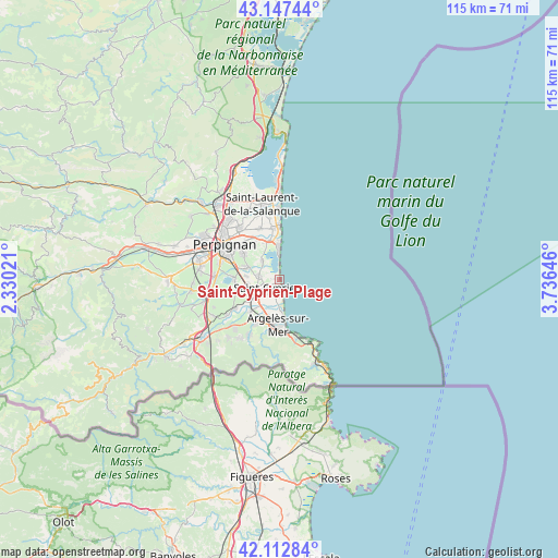
Saint-Cyprien-Plage GPS coordinates[2]
42° 37' 56.244" North, 3° 1' 59.988" East
| Map corner | latitude | longitude |
|---|---|---|
| Upper-left | 43.14744°, | 2.33021° |
| Center: | 42.63229°, | 3.03333° |
| Lower-right: | 42.11284°, | 3.73646° |
| Map W x H: | 115×115 km | = 71.5×71.5mi |
| max Lat: | 51.07786° ⇑99.2% North |
| Saint-Cyprien-Plage: | 42.63229° |
| min Lat: | ⇓0.8% South 41.3874° |
| min Long | Saint-Cyprien-P | max Long |
| -5.08615° | 3.03333° | 9.52242° |
| W 58.3%⇐ | ⇒41.7% E |
Elevation
Elevation of Saint-Cyprien-Plage is 2 m = 7 ft, and this is 191.7 m = 629 ft below average elevation for this country.
| Max E: |
2333 m = 7654 ft | 99.9% |
| Avg. | 193.7 m = 635 ft | |
| Saint-Cyprien-Plage | 2 m = 7 ft | |
Min E: |
-1 m = -3 ft | 0.1% |
See also: France elevation on elevation.city.
Geographical zone
Saint-Cyprien-Plage is located in North temperate zone (between Tropic of Cancer and the Arctic Circle). Distance of this Northern Tropic circle is 2134.3 km =1326.2 mi to South.| Distance of | km | miles | from Saint-Cyprien-Plage |
|---|---|---|---|
| North Pole | 5266.8 | 3272.6 | to North |
| Arctic Circle | 2660.9 | 1653.4 | to North |
| Tropic Cancer | 2134.3 | 1326.2 | to South |
| Equator | 4740.3 | 2945.5 | to South |


Nearby cities:
15 places around Saint-Cyprien-Plage: (largest is in red/bold)
• Alénya
4.3 km =2.7 mi,  279°
279°
• Argelers
9.5 km =5.9 mi,  185°
185°
• Cabestany
9.3 km =5.8 mi,  305°
305°
• Canet-en-Roussillon
7.7 km =4.8 mi,  349°
349°
• Corneilla-del-Vercol
6.7 km =4.2 mi,  262°
262°
• Elne
6.2 km =3.9 mi,  234°
234°
• Latour-Bas-Elne
3.8 km =2.4 mi,  221°
221°
• Montescot
8.7 km =5.4 mi,  251°
251°
• Palau-del-Vidre
9 km =5.6 mi, 221°
• Saint-Nazaire
5.2 km =3.2 mi,  319°
319°
• Sainte-Marie-Plage
10.3 km =6.4 mi,  1°
1°
• Saleilles
7 km =4.3 mi,  290°
290°
• Sant Andreu de Sureda
10.3 km =6.4 mi,  209°
209°
• Théza
6.8 km =4.2 mi, 275°
• Villeneuve-de-la-Raho
9.6 km =6 mi,  272°
272°
Sources, notices
• [Note1] Compared only with cities in France existing in our database
• [Src1] Map data: © OpenStreetMap contributors (CC-BY-SA)
• [Src2] Other city data from geonames.org with taken over terms of usage.
• [Src3] Geographical zone / Annual Mean Temperature by Robert A. Rohde @ Wikipedia
