Elne geodata
Elne (Occitanie) is a populated place; located in France in Europe/Paris (GMT+2) time zone. With population of 7,007 people, there are 1397 cities with bigger population in this country. Compared to other cities in France, 99.3% of cities are located further ↑North; 57.4% of cities are located further ←West and 90.7% of cities have higher elevation than Elne. Note1
Administrative division(s):
- Level 1: Occitanie
- Level 2: Département des Pyrénées-Orientales
- Level 3: Arrondissement de Céret
- Level 4: Elne


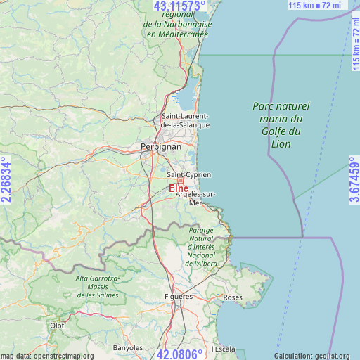
Elne GPS coordinates[2]
42° 36' 1.116" North, 2° 58' 17.256" East
| Map corner | latitude | longitude |
|---|---|---|
| Upper-left | 43.11573°, | 2.26834° |
| Center: | 42.60031°, | 2.97146° |
| Lower-right: | 42.0806°, | 3.67459° |
| Map W x H: | 115.1×115.1 km | = 71.5×71.5mi |
| max Lat: | 51.07786° ⇑99.3% North |
| Elne: | 42.60031° |
| min Lat: | ⇓0.7% South 41.3874° |
| min Long | Elne | max Long |
| -5.08615° | 2.97146° | 9.52242° |
| W 57.4%⇐ | ⇒42.6% E |
Elevation
Elevation of Elne is 28 m = 92 ft, and this is 165.7 m = 544 ft below average elevation for this country.
| Max E: |
2333 m = 7654 ft | 90.7% |
| Avg. | 193.7 m = 635 ft | |
| Elne | 28 m = 92 ft | |
Min E: |
-1 m = -3 ft | 9.3% |
See also: France elevation on elevation.city.
Geographical zone
Elne is located in North temperate zone (between Tropic of Cancer and the Arctic Circle). Distance of this Northern Tropic circle is 2130.8 km =1324 mi to South.| Distance of | km | miles | from Elne |
|---|---|---|---|
| North Pole | 5270.4 | 3274.9 | to North |
| Arctic Circle | 2664.5 | 1655.6 | to North |
| Tropic Cancer | 2130.8 | 1324 | to South |
| Equator | 4736.7 | 2943.2 | to South |


Nearby cities:
15 places around Elne: (largest is in red/bold)
• Alénya
4.4 km =2.7 mi,  10°
10°
• Argelers
7.2 km =4.5 mi,  144°
144°
• Bages
6.4 km =4 mi,  275°
275°
• Brouilla
6.7 km =4.2 mi,  236°
236°
• Corneilla-del-Vercol
3.1 km =1.9 mi,  328°
328°
• Latour-Bas-Elne
2.6 km =1.6 mi,  74°
74°
• Montescot
3.2 km =2 mi, 283°
• Ortaffa
4.3 km =2.7 mi, 238°
• Palau-del-Vidre
3.3 km =2.1 mi,  195°
195°
• Saint-Cyprien-Plage
6.2 km =3.9 mi,  54°
54°
• Saint-Génis-des-Fontaines
7.6 km =4.7 mi,  213°
213°
• Saleilles
6.2 km =3.9 mi,  345°
345°
• Sant Andreu de Sureda
5.4 km =3.4 mi,  180°
180°
• Théza
4.5 km =2.8 mi,  338°
338°
• Villeneuve-de-la-Raho
6 km =3.7 mi,  311°
311°
Sources, notices
• [Note1] Compared only with cities in France existing in our database
• [Src1] Map data: © OpenStreetMap contributors (CC-BY-SA)
• [Src2] Other city data from geonames.org with taken over terms of usage.
• [Src3] Geographical zone / Annual Mean Temperature by Robert A. Rohde @ Wikipedia
