Porto-Vecchio geodata
Porto-Vecchio (Corsica) is a populated place; located in France in Europe/Paris (GMT+2) time zone. With population of 11,820 people, there are 815 cities with bigger population in this country. Compared to other cities in France, 100% of cities are located further ↑North; 99.7% of cities are located further ←West and 79% of cities have higher elevation than Porto-Vecchio. Note1
Administrative division(s):
- Level 1: Corsica
- Level 2: Département de la Corse-du-Sud
- Level 3: Arrondissement de Sartène
- Level 4: Porto-Vecchio


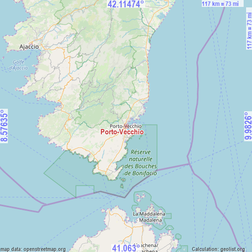
Porto-Vecchio GPS coordinates[2]
41° 35' 27.636" North, 9° 16' 46.092" East
| Map corner | latitude | longitude |
|---|---|---|
| Upper-left | 42.11474°, | 8.57635° |
| Center: | 41.59101°, | 9.27947° |
| Lower-right: | 41.063°, | 9.9826° |
| Map W x H: | 116.9×116.9 km | = 72.6×72.6mi |
| max Lat: | 51.07786° ⇑100% North |
| Porto-Vecchio: | 41.59101° |
| min Lat: | ⇓0% South 41.3874° |
| min Long | Porto-Vecchio | max Long |
| -5.08615° | 9.27947° | 9.52242° |
| W 99.7%⇐ | ⇒0.3% E |
Elevation
Elevation of Porto-Vecchio is 57 m = 187 ft, and this is 136.7 m = 448 ft below average elevation for this country.
| Max E: |
2333 m = 7654 ft | 79% |
| Avg. | 193.7 m = 635 ft | |
| Porto-Vecchio | 57 m = 187 ft | |
Min E: |
-1 m = -3 ft | 21% |
See also: France elevation on elevation.city.
Geographical zone
Porto-Vecchio is located in North temperate zone (between Tropic of Cancer and the Arctic Circle). Distance of this Northern Tropic circle is 2018.6 km =1254.3 mi to South.| Distance of | km | miles | from Porto-Vecchio |
|---|---|---|---|
| North Pole | 5382.6 | 3344.6 | to North |
| Arctic Circle | 2776.7 | 1725.4 | to North |
| Tropic Cancer | 2018.6 | 1254.3 | to South |
| Equator | 4624.5 | 2873.5 | to South |


Nearby cities:
15 places around Porto-Vecchio: (largest is in red/bold)
• Bonifacio
24.7 km =15.3 mi,  203°
203°
• Conca
16.5 km =10.3 mi,  15°
15°
• Figari
16.9 km =10.5 mi,  227°
227°
• Levie
17.8 km =11.1 mi,  313°
313°
• Olmeto
33.2 km =20.6 mi,  295°
295°
• Petreto
32.8 km =20.4 mi, 310°
• Pianottoli-Caldarello
21.5 km =13.4 mi,  239°
239°
• Propriano
32.6 km =20.3 mi,  286°
286°
• San-Gavino-di-Carbini
18.1 km =11.2 mi,  323°
323°
• Sari-Solenzara
28.3 km =17.6 mi, 16°
• Sartène
24.8 km =15.4 mi,  276°
276°
• Solaro
35.1 km =21.8 mi,  6°
6°
• Sotta
8.6 km =5.3 mi, 233°
• Ventiseri
39.5 km =24.5 mi, 6°
• Zonza
19.8 km =12.3 mi,  332°
332°
In other languages:
- In Spanish: Porto Vecchio
- In Italian: Porto Vecchio
- In Russian: Порто-Веккьо
- In Chinese: 韦基奥港
Sources, notices
• [Note1] Compared only with cities in France existing in our database
• [Src1] Map data: © OpenStreetMap contributors (CC-BY-SA)
• [Src2] Other city data from geonames.org with taken over terms of usage.
• [Src3] Geographical zone / Annual Mean Temperature by Robert A. Rohde @ Wikipedia
