Portel-des-Corbières geodata
Portel-des-Corbières (Occitanie) is a populated place; located in France in Europe/Paris (GMT+2) time zone. With population of 1,119 people, there are 8016 cities with bigger population in this country. Compared to other cities in France, 98.2% of cities are located further ↑North; 56.6% of cities are located further ←West and 82.6% of cities have higher elevation than Portel-des-Corbières. Note1
Administrative division(s):
- Level 1: Occitanie
- Level 2: Département de l'Aude
- Level 3: Arrondissement de Narbonne
- Level 4: Portel-des-Corbières
Current local time in Portel-des-Corbières:
01:40 PM, WednesdayDifference from your time zone: hours


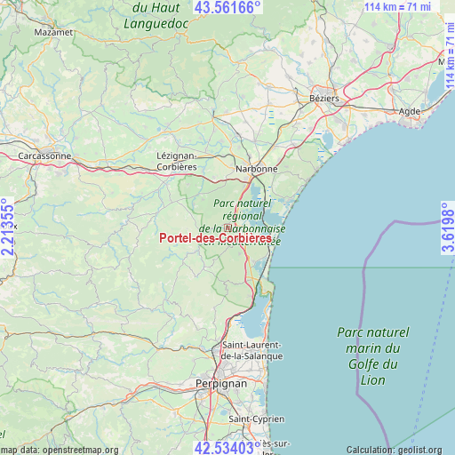
Portel-des-Corbières GPS coordinates[2]
43° 3' 0" North, 2° 55' 0.012" East
| Map corner | latitude | longitude |
|---|---|---|
| Upper-left | 43.56166°, | 2.21355° |
| Center: | 43.05°, | 2.91667° |
| Lower-right: | 42.53403°, | 3.6198° |
| Map W x H: | 114.3×114.3 km | = 71×71mi |
| max Lat: | 51.07786° ⇑98.2% North |
| Portel-des-Corbières: | 43.05° |
| min Lat: | ⇓1.8% South 41.3874° |
| min Long | Portel-des-Corb | max Long |
| -5.08615° | 2.91667° | 9.52242° |
| W 56.6%⇐ | ⇒43.4% E |
Elevation
Elevation of Portel-des-Corbières is 48 m = 157 ft, and this is 145.7 m = 478 ft below average elevation for this country.
| Max E: |
2333 m = 7654 ft | 82.6% |
| Avg. | 193.7 m = 635 ft | |
| Portel-des-Corbières | 48 m = 157 ft | |
Min E: |
-1 m = -3 ft | 17.4% |
See also: France elevation on elevation.city.
Geographical zone
Portel-des-Corbières is located in North temperate zone (between Tropic of Cancer and the Arctic Circle). Distance of this Northern Tropic circle is 2180.8 km =1355.1 mi to South.| Distance of | km | miles | from Portel-des-Corbières |
|---|---|---|---|
| North Pole | 5220.4 | 3243.8 | to North |
| Arctic Circle | 2614.5 | 1624.6 | to North |
| Tropic Cancer | 2180.8 | 1355.1 | to South |
| Equator | 4786.7 | 2974.3 | to South |


Nearby cities:
15 places around Portel-des-Corbières: (largest is in red/bold)
• Bages
10.1 km =6.3 mi,  36°
36°
• Bizanet
13.2 km =8.2 mi,  343°
343°
• Boutenac
14.9 km =9.3 mi,  316°
316°
• Caves
14.1 km =8.8 mi,  159°
159°
• Durban-Corbières
10.2 km =6.3 mi,  233°
233°
• Gruissan
15.2 km =9.4 mi,  65°
65°
• La Palme
10.4 km =6.5 mi,  143°
143°
• Montredon-des-Corbières
14.9 km =9.3 mi,  5°
5°
• Ornaisons
15.9 km =9.9 mi, 335°
• Peyriac-de-Mer
5.3 km =3.3 mi, 39°
• Port-la-Nouvelle
10.8 km =6.7 mi,  107°
107°
• Roquefort-des-Corbières
7.2 km =4.5 mi, 155°
• Saint-André-de-Roquelongue
9.7 km =6 mi, 317°
• Sigean
5.6 km =3.5 mi,  115°
115°
• Thézan-des-Corbières
13.4 km =8.3 mi,  294°
294°
Sources, notices
• [Note1] Compared only with cities in France existing in our database
• [Src1] Map data: © OpenStreetMap contributors (CC-BY-SA)
• [Src2] Other city data from geonames.org with taken over terms of usage.
• [Src3] Geographical zone / Annual Mean Temperature by Robert A. Rohde @ Wikipedia
