Durban-Corbières geodata
Durban-Corbières (Occitanie) is a populated place; located in France in Europe/Paris (GMT+2) time zone. With population of 658 people, there are 12412 cities with bigger population in this country. Compared to other cities in France, 98.4% of cities are located further ↑North; 55.2% of cities are located further ←West and 57.3% of cities have higher elevation than Durban-Corbières. Note1
Administrative division(s):
- Level 1: Occitanie
- Level 2: Département de l'Aude
- Level 3: Arrondissement de Narbonne
- Level 4: Durban-Corbières


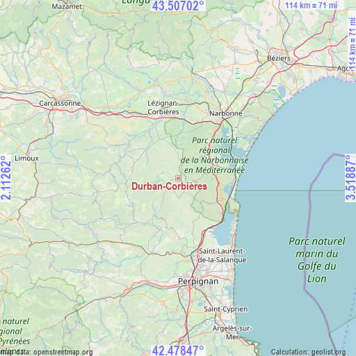
Durban-Corbières GPS coordinates[2]
42° 59' 41.64" North, 2° 48' 56.664" East
| Map corner | latitude | longitude |
|---|---|---|
| Upper-left | 43.50702°, | 2.11262° |
| Center: | 42.9949°, | 2.81574° |
| Lower-right: | 42.47847°, | 3.51887° |
| Map W x H: | 114.4×114.4 km | = 71.1×71.1mi |
| max Lat: | 51.07786° ⇑98.4% North |
| Durban-Corbières: | 42.9949° |
| min Lat: | ⇓1.6% South 41.3874° |
| min Long | Durban-Corbièr | max Long |
| -5.08615° | 2.81574° | 9.52242° |
| W 55.2%⇐ | ⇒44.8% E |
Elevation
Elevation of Durban-Corbières is 110 m = 361 ft, and this is 83.7 m = 275 ft below average elevation for this country.
| Max E: |
2333 m = 7654 ft | 57.3% |
| Avg. | 193.7 m = 635 ft | |
| Durban-Corbières | 110 m = 361 ft | |
Min E: |
-1 m = -3 ft | 42.7% |
See also: France elevation on elevation.city.
Geographical zone
Durban-Corbières is located in North temperate zone (between Tropic of Cancer and the Arctic Circle). Distance of this Northern Tropic circle is 2174.7 km =1351.3 mi to South.| Distance of | km | miles | from Durban-Corbières |
|---|---|---|---|
| North Pole | 5226.5 | 3247.6 | to North |
| Arctic Circle | 2620.6 | 1628.4 | to North |
| Tropic Cancer | 2174.7 | 1351.3 | to South |
| Equator | 4780.6 | 2970.5 | to South |


Nearby cities:
15 places around Durban-Corbières: (largest is in red/bold)
• Boutenac
17.1 km =10.6 mi,  353°
353°
• Caves
14.9 km =9.3 mi,  118°
118°
• Fitou
17.3 km =10.7 mi,  130°
130°
• La Palme
14.5 km =9 mi,  98°
98°
• Opoul-Périllos
15.3 km =9.5 mi,  158°
158°
• Paziols
17.1 km =10.6 mi,  207°
207°
• Peyriac-de-Mer
15.5 km =9.6 mi,  48°
48°
• Portel-des-Corbières
10.2 km =6.3 mi, 53°
• Roquefort-des-Corbières
11.2 km =7 mi,  92°
92°
• Saint-André-de-Roquelongue
13.5 km =8.4 mi,  7°
7°
• Saint-Laurent-de-la-Cabrerisse
13.7 km =8.5 mi,  317°
317°
• Sigean
13.8 km =8.6 mi,  74°
74°
• Thézan-des-Corbières
12.3 km =7.6 mi,  341°
341°
• Tuchan
14.3 km =8.9 mi, 213°
• Vingrau
16.6 km =10.3 mi,  190°
190°
Sources, notices
• [Note1] Compared only with cities in France existing in our database
• [Src1] Map data: © OpenStreetMap contributors (CC-BY-SA)
• [Src2] Other city data from geonames.org with taken over terms of usage.
• [Src3] Geographical zone / Annual Mean Temperature by Robert A. Rohde @ Wikipedia
