Aurec-sur-Loire geodata
Aurec-sur-Loire (Auvergne-Rhône-Alpes) is a populated place; located in France in Europe/Paris (GMT+2) time zone. With population of 5,226 people, there are 1884 cities with bigger population in this country. Compared to other cities in France, 75.6% of cities are located further ↑North; 69.7% of cities are located further ←West and 93.1% of cities have lower elevation than Aurec-sur-Loire. Note1
Administrative division(s):
- Level 1: Auvergne-Rhône-Alpes
- Level 2: Haute-Loire
- Level 3: Yssingeaux
- Level 4: Aurec-sur-Loire


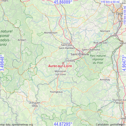
Aurec-sur-Loire GPS coordinates[2]
45° 22' 8.688" North, 4° 12' 5.796" East
| Map corner | latitude | longitude |
|---|---|---|
| Upper-left | 45.86089°, | 3.49848° |
| Center: | 45.36908°, | 4.20161° |
| Lower-right: | 44.87295°, | 4.90473° |
| Map W x H: | 109.8×109.8 km | = 68.2×68.2mi |
| max Lat: | 51.07786° ⇑75.6% North |
| Aurec-sur-Loire: | 45.36908° |
| min Lat: | ⇓24.4% South 41.3874° |
| min Long | Aurec-sur-Loire | max Long |
| -5.08615° | 4.20161° | 9.52242° |
| W 69.7%⇐ | ⇒30.3% E |
Elevation
Elevation of Aurec-sur-Loire is 508 m = 1667 ft, and this is 314.3 m = 1031 ft above average elevation for this country.
| Max E: |
2333 m = 7654 ft | 6.9% |
| Aurec-sur-Loire | 508 m 1667 ft | |
| Avg. | 193.7 m = 635 ft | |
Min E: |
-1 m = -3 ft | 93.1% |
See also: France elevation on elevation.city.
Geographical zone
Aurec-sur-Loire is located in North temperate zone (between Tropic of Cancer and the Arctic Circle). Distance of this North polar circle is 2356.6 km =1464.3 mi to North.| Distance of | km | miles | from Aurec-sur-Loire |
|---|---|---|---|
| North Pole | 4962.5 | 3083.6 | to North |
| Arctic Circle | 2356.6 | 1464.3 | to North |
| Tropic Cancer | 2438.6 | 1515.3 | to South |
| Equator | 5044.6 | 3134.6 | to South |


Nearby cities:
15 places around Aurec-sur-Loire: (largest is in red/bold)
• Bas-en-Basset
10.1 km =6.3 mi,  225°
225°
• Chambles
8.8 km =5.5 mi,  16°
16°
• Firminy
7.2 km =4.5 mi,  71°
71°
• Fraisses
5.3 km =3.3 mi, 66°
• La Séauve-sur-Semène
9 km =5.6 mi,  155°
155°
• Le Chambon-Feugerolles
9.7 km =6 mi,  75°
75°
• Monistrol-sur-Loire
8.8 km =5.5 mi,  195°
195°
• Pont-Salomon
5 km =3.1 mi,  133°
133°
• Périgneux
8.7 km =5.4 mi,  335°
335°
• Saint-Didier-en-Velay
9.4 km =5.8 mi,  142°
142°
• Saint-Just-Malmont
9.3 km =5.8 mi,  110°
110°
• Saint-Maurice-en-Gourgois
3.9 km =2.4 mi, 337°
• Saint-Nizier-de-Fornas
10.1 km =6.3 mi,  292°
292°
• Saint-Paul
3.8 km =2.4 mi,  30°
30°
• Unieux
6.7 km =4.2 mi,  54°
54°
Sources, notices
• [Note1] Compared only with cities in France existing in our database
• [Src1] Map data: © OpenStreetMap contributors (CC-BY-SA)
• [Src2] Other city data from geonames.org with taken over terms of usage.
• [Src3] Geographical zone / Annual Mean Temperature by Robert A. Rohde @ Wikipedia
