Pont-Sainte-Maxence geodata
Pont-Sainte-Maxence (Hauts-de-France) is a populated place; located in France in Europe/Paris (GMT+2) time zone. With population of 13,732 people, there are 691 cities with bigger population in this country. Compared to other cities in France, 86.1% of cities are located further ↓South; 52.1% of cities are located further ←West and 87.1% of cities have higher elevation than Pont-Sainte-Maxence. Note1
Administrative division(s):
- Level 1: Hauts-de-France
- Level 2: Département de l'Oise
- Level 3: Arrondissement de Senlis
- Level 4: Pont-Sainte-Maxence


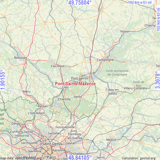
Pont-Sainte-Maxence GPS coordinates[2]
49° 18' 6.048" North, 2° 36' 16.812" East
| Map corner | latitude | longitude |
|---|---|---|
| Upper-left | 49.75804°, | 1.90155° |
| Center: | 49.30168°, | 2.60467° |
| Lower-right: | 48.84105°, | 3.3078° |
| Map W x H: | 102×102 km | = 63.4×63.4mi |
| max Lat: | 51.07786° ⇑13.9% North |
| Pont-Sainte-Maxence: | 49.30168° |
| min Lat: | ⇓86.1% South 41.3874° |
| min Long | Pont-Sainte-Max | max Long |
| -5.08615° | 2.60467° | 9.52242° |
| W 52.1%⇐ | ⇒47.9% E |
Elevation
Elevation of Pont-Sainte-Maxence is 37 m = 121 ft, and this is 156.7 m = 514 ft below average elevation for this country.
| Max E: |
2333 m = 7654 ft | 87.1% |
| Avg. | 193.7 m = 635 ft | |
| Pont-Sainte-Maxence | 37 m = 121 ft | |
Min E: |
-1 m = -3 ft | 12.9% |
See also: France elevation on elevation.city.
Geographical zone
Pont-Sainte-Maxence is located in North temperate zone (between Tropic of Cancer and the Arctic Circle). Distance of this North polar circle is 1919.3 km =1192.6 mi to North.| Distance of | km | miles | from Pont-Sainte-Maxence |
|---|---|---|---|
| North Pole | 4525.2 | 2811.8 | to North |
| Arctic Circle | 1919.3 | 1192.6 | to North |
| Tropic Cancer | 2875.9 | 1787 | to South |
| Equator | 5481.8 | 3406.2 | to South |


Nearby cities:
15 places around Pont-Sainte-Maxence: (largest is in red/bold)
• Brenouille
4.4 km =2.7 mi,  275°
275°
• Cinqueux
5.7 km =3.5 mi,  287°
287°
• Fleurines
5 km =3.1 mi,  197°
197°
• Houdancourt
5.4 km =3.4 mi,  28°
28°
• Les Ageux
1.7 km =1.1 mi,  348°
348°
• Monceaux
4.3 km =2.7 mi,  295°
295°
• Pontpoint
3.3 km =2.1 mi,  93°
93°
• Rieux
6.4 km =4 mi,  268°
268°
• Sacy-le-Grand
7.3 km =4.5 mi,  323°
323°
• Sacy-le-Petit
6.8 km =4.2 mi,  15°
15°
• Saint-Martin-Longueau
4.6 km =2.9 mi,  358°
358°
• Saint-Pierre
3.8 km =2.4 mi, 91°
• Verneuil-en-Halatte
6.4 km =4 mi,  246°
246°
• Villeneuve-sur-Verberie
6.9 km =4.3 mi,  115°
115°
• Villers-Saint-Frambourg
5.8 km =3.6 mi,  153°
153°
Sources, notices
• [Note1] Compared only with cities in France existing in our database
• [Src1] Map data: © OpenStreetMap contributors (CC-BY-SA)
• [Src2] Other city data from geonames.org with taken over terms of usage.
• [Src3] Geographical zone / Annual Mean Temperature by Robert A. Rohde @ Wikipedia
