Pontorson geodata
Pontorson (Normandy) is a populated place; located in France in Europe/Paris (GMT+2) time zone. With population of 4,147 people, there are 2367 cities with bigger population in this country. Compared to other cities in France, 69.6% of cities are located further ↓South; 92.3% of cities are located further →East and 94.7% of cities have higher elevation than Pontorson. Note1


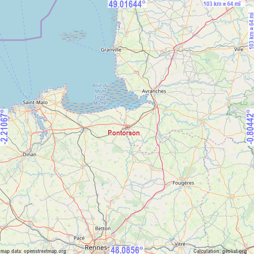
Pontorson GPS coordinates[2]
48° 33' 11.376" North, 1° 30' 27.144" West
| Map corner | latitude | longitude |
|---|---|---|
| Upper-left | 49.01644°, | -2.21067° |
| Center: | 48.55316°, | -1.50754° |
| Lower-right: | 48.0856°, | -0.80442° |
| Map W x H: | 103.5×103.5 km | = 64.3×64.3mi |
| max Lat: | 51.07786° ⇑30.4% North |
| Pontorson: | 48.55316° |
| min Lat: | ⇓69.6% South 41.3874° |
| min Long | Pontorson | max Long |
| -5.08615° | -1.50754° | 9.52242° |
| W 7.7%⇐ | ⇒92.3% E |
Elevation
Elevation of Pontorson is 18 m = 59 ft, and this is 175.7 m = 576 ft below average elevation for this country.
| Max E: |
2333 m = 7654 ft | 94.7% |
| Avg. | 193.7 m = 635 ft | |
| Pontorson | 18 m = 59 ft | |
Min E: |
-1 m = -3 ft | 5.3% |
See also: France elevation on elevation.city.
Geographical zone
Pontorson is located in North temperate zone (between Tropic of Cancer and the Arctic Circle). Distance of this North polar circle is 2002.6 km =1244.4 mi to North.| Distance of | km | miles | from Pontorson |
|---|---|---|---|
| North Pole | 4608.5 | 2863.6 | to North |
| Arctic Circle | 2002.6 | 1244.4 | to North |
| Tropic Cancer | 2792.7 | 1735.3 | to South |
| Equator | 5398.6 | 3354.5 | to South |


Nearby cities:
15 places around Pontorson: (largest is in red/bold)
• Antrain
10.5 km =6.5 mi,  170°
170°
• Argouges
9.9 km =6.2 mi,  124°
124°
• Baguer-Pican
14 km =8.7 mi,  269°
269°
• Bazouges-la-Pérouse
15 km =9.3 mi,  199°
199°
• Coglès
14.8 km =9.2 mi,  134°
134°
• La Boussac
12.2 km =7.6 mi,  248°
248°
• La Fontenelle
9.6 km =6 mi,  178°
178°
• Pleine-Fougères
4.8 km =3 mi,  242°
242°
• Roz-sur-Couesnon
7.4 km =4.6 mi,  302°
302°
• Sacey
6.5 km =4 mi,  139°
139°
• Saint-Broladre
11.7 km =7.3 mi,  288°
288°
• Saint-James
13.8 km =8.6 mi,  104°
104°
• Sougéal
4.9 km =3 mi,  193°
193°
• Trans-la-Forêt
9 km =5.6 mi,  229°
229°
• Tremblay
14.8 km =9.2 mi, 170°
Sources, notices
• [Note1] Compared only with cities in France existing in our database
• [Src1] Map data: © OpenStreetMap contributors (CC-BY-SA)
• [Src2] Other city data from geonames.org with taken over terms of usage.
• [Src3] Geographical zone / Annual Mean Temperature by Robert A. Rohde @ Wikipedia
