Nandy geodata
Nandy (Île-de-France) is a populated place; located in France in Europe/Paris (GMT+2) time zone. With population of 6,741 people, there are 1474 cities with bigger population in this country. Compared to other cities in France, 70.4% of cities are located further ↓South; 51.6% of cities are located further ←West and 68.3% of cities have higher elevation than Nandy. Note1
Administrative division(s):
- Level 1: Île-de-France
- Level 2: Seine-et-Marne
- Level 3: Arrondissement de Melun
- Level 4: Nandy


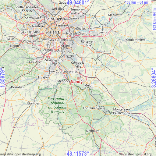
Nandy GPS coordinates[2]
48° 34' 58.836" North, 2° 33' 46.512" East
| Map corner | latitude | longitude |
|---|---|---|
| Upper-left | 49.04601°, | 1.85979° |
| Center: | 48.58301°, | 2.56292° |
| Lower-right: | 48.11573°, | 3.26604° |
| Map W x H: | 103.4×103.4 km | = 64.2×64.2mi |
| max Lat: | 51.07786° ⇑29.6% North |
| Nandy: | 48.58301° |
| min Lat: | ⇓70.4% South 41.3874° |
| min Long | Nandy | max Long |
| -5.08615° | 2.56292° | 9.52242° |
| W 51.6%⇐ | ⇒48.4% E |
Elevation
Elevation of Nandy is 82 m = 269 ft, and this is 111.7 m = 366 ft below average elevation for this country.
| Max E: |
2333 m = 7654 ft | 68.3% |
| Avg. | 193.7 m = 635 ft | |
| Nandy | 82 m = 269 ft | |
Min E: |
-1 m = -3 ft | 31.7% |
See also: France elevation on elevation.city.
Geographical zone
Nandy is located in North temperate zone (between Tropic of Cancer and the Arctic Circle). Distance of this North polar circle is 1999.2 km =1242.2 mi to North.| Distance of | km | miles | from Nandy |
|---|---|---|---|
| North Pole | 4605.1 | 2861.5 | to North |
| Arctic Circle | 1999.2 | 1242.2 | to North |
| Tropic Cancer | 2796 | 1737.4 | to South |
| Equator | 5401.9 | 3356.6 | to South |


Nearby cities:
15 places around Nandy: (largest is in red/bold)
• Boissise-la-Bertrand
6.4 km =4 mi,  162°
162°
• Boissise-le-Roi
6.5 km =4 mi,  175°
175°
• Cesson
4.1 km =2.5 mi,  125°
125°
• Corbeil-Essonnes
6.1 km =3.8 mi,  294°
294°
• Le Coudray-Montceaux
5.1 km =3.2 mi,  245°
245°
• Lieusaint
5.9 km =3.7 mi,  349°
349°
• Moissy-Cramayel
5.6 km =3.5 mi,  30°
30°
• Ponthierry
5.7 km =3.5 mi,  194°
194°
• Réau
5.4 km =3.4 mi,  56°
56°
• Saint-Fargeau-Ponthierry
3.8 km =2.4 mi,  221°
221°
• Saint-Pierre-du-Perray
5.9 km =3.7 mi,  301°
301°
• Saintry-sur-Seine
5.2 km =3.2 mi, 286°
• Savigny-le-Temple
1.8 km =1.1 mi,  124°
124°
• Seine-Port
2.9 km =1.8 mi, 194°
• Vert-Saint-Denis
4.5 km =2.8 mi,  111°
111°
Sources, notices
• [Note1] Compared only with cities in France existing in our database
• [Src1] Map data: © OpenStreetMap contributors (CC-BY-SA)
• [Src2] Other city data from geonames.org with taken over terms of usage.
• [Src3] Geographical zone / Annual Mean Temperature by Robert A. Rohde @ Wikipedia
