Villefranche-sur-Saône geodata
Villefranche-sur-Saône (Auvergne-Rhône-Alpes) is a seat of a third-order administrative division; located in France in Europe/Paris (GMT+2) time zone. With population of 32,994 people, there are 238 cities with bigger population in this country. Compared to other cities in France, 66.4% of cities are located further ↑North; 74% of cities are located further ←West and 61.6% of cities have lower elevation than Villefranche-sur-Saône. Note1
Administrative division(s):
- Level 1: Auvergne-Rhône-Alpes
- Level 2: Département du Rhône
- Level 3: Arrondissement de Villefranche-sur-Saône
- Level 4: Villefranche-sur-Saône
Current local time in Villefranche-sur-Saône:
06:00 AM, WednesdayDifference from your time zone: hours


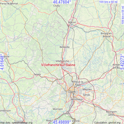
Villefranche-sur-Saône GPS coordinates[2]
45° 59' 22.812" North, 4° 43' 10.596" East
| Map corner | latitude | longitude |
|---|---|---|
| Upper-left | 46.47604°, | 4.01648° |
| Center: | 45.98967°, | 4.71961° |
| Lower-right: | 45.49899°, | 5.42273° |
| Map W x H: | 108.6×108.6 km | = 67.5×67.5mi |
| max Lat: | 51.07786° ⇑66.4% North |
| Villefranche-sur-Saône: | 45.98967° |
| min Lat: | ⇓33.6% South 41.3874° |
| min Long | Villefranche-su | max Long |
| -5.08615° | 4.71961° | 9.52242° |
| W 74%⇐ | ⇒26% E |
Elevation
Elevation of Villefranche-sur-Saône is 178 m = 584 ft, and this is 15.7 m = 52 ft below average elevation for this country.
| Max E: |
2333 m = 7654 ft | 38.4% |
| Avg. | 193.7 m = 635 ft | |
| Villefranche-sur-Saône | 178 m = 584 ft | |
Min E: |
-1 m = -3 ft | 61.6% |
See also: France elevation on elevation.city.
Geographical zone
Villefranche-sur-Saône is located in North temperate zone (between Tropic of Cancer and the Arctic Circle). Distance of this North polar circle is 2287.6 km =1421.4 mi to North.| Distance of | km | miles | from Villefranche-sur-Saône |
|---|---|---|---|
| North Pole | 4893.5 | 3040.7 | to North |
| Arctic Circle | 2287.6 | 1421.4 | to North |
| Tropic Cancer | 2507.7 | 1558.2 | to South |
| Equator | 5113.6 | 3177.4 | to South |


Nearby cities:
15 places around Villefranche-sur-Saône: (largest is in red/bold)
• Anse
6 km =3.7 mi,  180°
180°
• Arnas
3.9 km =2.4 mi,  346°
346°
• Beauregard
2.9 km =1.8 mi,  68°
68°
• Denicé
5.9 km =3.7 mi,  283°
283°
• Fareins
4.6 km =2.9 mi,  44°
44°
• Frans
4.5 km =2.8 mi,  85°
85°
• Gleizé
1.7 km =1.1 mi,  268°
268°
• Jassans-Riottier
3.4 km =2.1 mi,  106°
106°
• Lacenas
5.8 km =3.6 mi, 267°
• Liergues
4.9 km =3 mi,  245°
245°
• Limas
1.9 km =1.2 mi,  214°
214°
• Pommiers
4.3 km =2.7 mi, 208°
• Saint-Didier-de-Formans
6 km =3.7 mi,  123°
123°
• Sainte-Euphémie
6.4 km =4 mi, 108°
• Trévoux
6.6 km =4.1 mi,  142°
142°
Sources, notices
• [Note1] Compared only with cities in France existing in our database
• [Src1] Map data: © OpenStreetMap contributors (CC-BY-SA)
• [Src2] Other city data from geonames.org with taken over terms of usage.
• [Src3] Geographical zone / Annual Mean Temperature by Robert A. Rohde @ Wikipedia
