Plounéour-Ménez geodata
Plounéour-Ménez (Brittany) is a populated place; located in France in Europe/Paris (GMT+2) time zone. With population of 1,229 people, there are 7384 cities with bigger population in this country. Compared to other cities in France, 67.2% of cities are located further ↓South; 98.9% of cities are located further →East and 73.2% of cities have lower elevation than Plounéour-Ménez. Note1
Administrative division(s):
- Level 1: Brittany
- Level 2: Département du Finistère
- Level 3: Arrondissement de Morlaix
- Level 4: Plounéour-Ménez


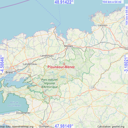
Plounéour-Ménez GPS coordinates[2]
48° 27' 0" North, 3° 52' 59.988" West
| Map corner | latitude | longitude |
|---|---|---|
| Upper-left | 48.91422°, | -4.58646° |
| Center: | 48.45°, | -3.88333° |
| Lower-right: | 47.98149°, | -3.18021° |
| Map W x H: | 103.7×103.7 km | = 64.4×64.4mi |
| max Lat: | 51.07786° ⇑32.8% North |
| Plounéour-Ménez: | 48.45° |
| min Lat: | ⇓67.2% South 41.3874° |
| min Long | Plounéour-Mén | max Long |
| -5.08615° | -3.88333° | 9.52242° |
| W 1.1%⇐ | ⇒98.9% E |
Elevation
Elevation of Plounéour-Ménez is 237 m = 778 ft, and this is 43.3 m = 142 ft above average elevation for this country.
| Max E: |
2333 m = 7654 ft | 26.8% |
| Plounéour-Ménez | 237 m 778 ft | |
| Avg. | 193.7 m = 635 ft | |
Min E: |
-1 m = -3 ft | 73.2% |
See also: France elevation on elevation.city.
Geographical zone
Plounéour-Ménez is located in North temperate zone (between Tropic of Cancer and the Arctic Circle). Distance of this North polar circle is 2014 km =1251.4 mi to North.| Distance of | km | miles | from Plounéour-Ménez |
|---|---|---|---|
| North Pole | 4619.9 | 2870.7 | to North |
| Arctic Circle | 2014 | 1251.4 | to North |
| Tropic Cancer | 2781.2 | 1728.2 | to South |
| Equator | 5387.1 | 3347.4 | to South |


Nearby cities:
15 places around Plounéour-Ménez: (largest is in red/bold)
• Berrien
11 km =6.8 mi,  118°
118°
• Commana
6.7 km =4.2 mi,  232°
232°
• Guiclan
12.5 km =7.8 mi,  332°
332°
• Guimiliau
9.4 km =5.8 mi,  296°
296°
• Huelgoat
14.2 km =8.8 mi,  134°
134°
• La Feuillée
6.8 km =4.2 mi,  162°
162°
• Lampaul-Guimiliau
12.5 km =7.8 mi,  291°
291°
• Le Cloître-Saint-Thégonnec
7.4 km =4.6 mi,  63°
63°
• Morlaix
14.7 km =9.1 mi,  16°
16°
• Pleyber-Christ
5.7 km =3.5 mi,  12°
12°
• Plougonven
14.3 km =8.9 mi, 58°
• Plourin-lès-Morlaix
11.8 km =7.3 mi,  38°
38°
• Saint-Sauveur
8.6 km =5.3 mi,  270°
270°
• Saint-Thégonnec
8.9 km =5.5 mi, 326°
• Sainte-Sève
13 km =8.1 mi, 5°
Sources, notices
• [Note1] Compared only with cities in France existing in our database
• [Src1] Map data: © OpenStreetMap contributors (CC-BY-SA)
• [Src2] Other city data from geonames.org with taken over terms of usage.
• [Src3] Geographical zone / Annual Mean Temperature by Robert A. Rohde @ Wikipedia
