Ploërmel geodata
Ploërmel (Brittany) is a populated place; located in France in Europe/Paris (GMT+2) time zone. With population of 8,422 people, there are 1153 cities with bigger population in this country. Compared to other cities in France, 58.1% of cities are located further ↓South; 96% of cities are located further →East and 70.1% of cities have higher elevation than Ploërmel. Note1
Administrative division(s):
- Level 1: Brittany
- Level 2: Morbihan
- Level 3: Arrondissement de Pontivy
- Level 4: Ploërmel


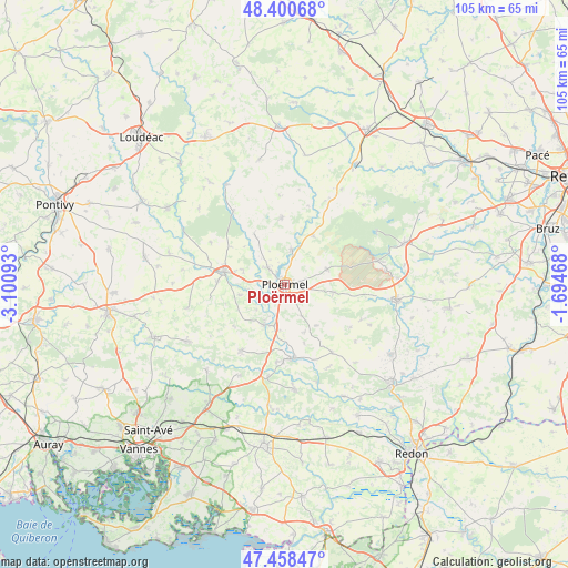
Ploërmel GPS coordinates[2]
47° 55' 54.192" North, 2° 23' 52.116" West
| Map corner | latitude | longitude |
|---|---|---|
| Upper-left | 48.40068°, | -3.10093° |
| Center: | 47.93172°, | -2.39781° |
| Lower-right: | 47.45847°, | -1.69468° |
| Map W x H: | 104.8×104.8 km | = 65.1×65.1mi |
| max Lat: | 51.07786° ⇑41.9% North |
| Ploërmel: | 47.93172° |
| min Lat: | ⇓58.1% South 41.3874° |
| min Long | Ploërmel | max Long |
| -5.08615° | -2.39781° | 9.52242° |
| W 4%⇐ | ⇒96% E |
Elevation
Elevation of Ploërmel is 78 m = 256 ft, and this is 115.7 m = 380 ft below average elevation for this country.
| Max E: |
2333 m = 7654 ft | 70.1% |
| Avg. | 193.7 m = 635 ft | |
| Ploërmel | 78 m = 256 ft | |
Min E: |
-1 m = -3 ft | 29.9% |
See also: France elevation on elevation.city.
Geographical zone
Ploërmel is located in North temperate zone (between Tropic of Cancer and the Arctic Circle). Distance of this North polar circle is 2071.7 km =1287.3 mi to North.| Distance of | km | miles | from Ploërmel |
|---|---|---|---|
| North Pole | 4677.6 | 2906.5 | to North |
| Arctic Circle | 2071.7 | 1287.3 | to North |
| Tropic Cancer | 2723.6 | 1692.4 | to South |
| Equator | 5329.5 | 3311.6 | to South |


Nearby cities:
15 places around Ploërmel: (largest is in red/bold)
• Augan
9 km =5.6 mi,  98°
98°
• Campénéac
8.3 km =5.2 mi,  69°
69°
• Caro
9.5 km =5.9 mi,  142°
142°
• Guillac
5.6 km =3.5 mi,  245°
245°
• Guégon
12.4 km =7.7 mi,  272°
272°
• Josselin
11.5 km =7.1 mi,  284°
284°
• La Croix-Helléan
8.2 km =5.1 mi,  290°
290°
• Le Roc-Saint-André
8.5 km =5.3 mi,  206°
206°
• Lizio
12.2 km =7.6 mi,  231°
231°
• Loyat
6.5 km =4 mi,  9°
9°
• Missiriac
11.3 km =7 mi,  161°
161°
• Néant-sur-Yvel
10.4 km =6.5 mi,  29°
29°
• Saint-Malo-des-Trois-Fontaines
10.7 km =6.6 mi,  328°
328°
• Saint-Servant
8.7 km =5.4 mi,  257°
257°
• Taupont
4.4 km =2.7 mi,  315°
315°
Sources, notices
• [Note1] Compared only with cities in France existing in our database
• [Src1] Map data: © OpenStreetMap contributors (CC-BY-SA)
• [Src2] Other city data from geonames.org with taken over terms of usage.
• [Src3] Geographical zone / Annual Mean Temperature by Robert A. Rohde @ Wikipedia
