Guégon geodata
Guégon (Brittany) is a populated place; located in France in Europe/Paris (GMT+2) time zone. With population of 2,587 people, there are 3770 cities with bigger population in this country. Compared to other cities in France, 58.2% of cities are located further ↓South; 96.4% of cities are located further →East and 65.3% of cities have higher elevation than Guégon. Note1
Administrative division(s):
- Level 1: Brittany
- Level 2: Morbihan
- Level 3: Arrondissement de Pontivy
- Level 4: Guégon


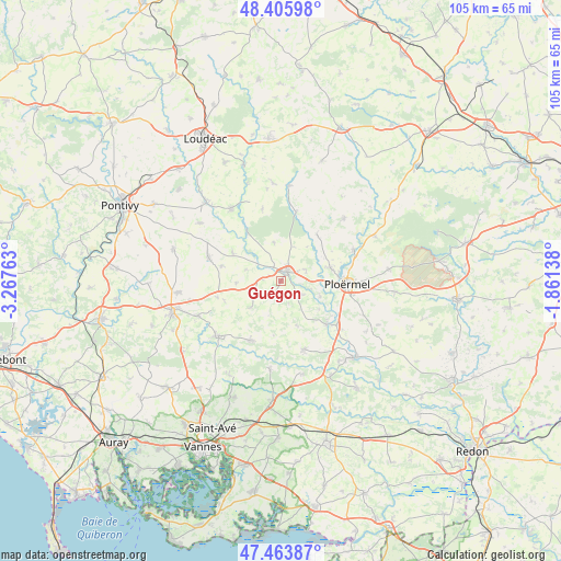
Guégon GPS coordinates[2]
47° 56' 13.452" North, 2° 33' 52.2" West
| Map corner | latitude | longitude |
|---|---|---|
| Upper-left | 48.40598°, | -3.26763° |
| Center: | 47.93707°, | -2.5645° |
| Lower-right: | 47.46387°, | -1.86138° |
| Map W x H: | 104.8×104.8 km | = 65.1×65.1mi |
| max Lat: | 51.07786° ⇑41.8% North |
| Guégon: | 47.93707° |
| min Lat: | ⇓58.2% South 41.3874° |
| min Long | Guégon | max Long |
| -5.08615° | -2.5645° | 9.52242° |
| W 3.6%⇐ | ⇒96.4% E |
Elevation
Elevation of Guégon is 89 m = 292 ft, and this is 104.7 m = 344 ft below average elevation for this country.
| Max E: |
2333 m = 7654 ft | 65.3% |
| Avg. | 193.7 m = 635 ft | |
| Guégon | 89 m = 292 ft | |
Min E: |
-1 m = -3 ft | 34.7% |
See also: France elevation on elevation.city.
Geographical zone
Guégon is located in North temperate zone (between Tropic of Cancer and the Arctic Circle). Distance of this North polar circle is 2071.1 km =1286.9 mi to North.| Distance of | km | miles | from Guégon |
|---|---|---|---|
| North Pole | 4677 | 2906.2 | to North |
| Arctic Circle | 2071.1 | 1286.9 | to North |
| Tropic Cancer | 2724.2 | 1692.7 | to South |
| Equator | 5330.1 | 3312 | to South |


Nearby cities:
15 places around Guégon: (largest is in red/bold)
• Cruguel
6.9 km =4.3 mi,  199°
199°
• Guillac
7.9 km =4.9 mi,  111°
111°
• Guéhenno
7.5 km =4.7 mi,  228°
228°
• Josselin
2.6 km =1.6 mi,  30°
30°
• La Croix-Helléan
5.2 km =3.2 mi,  64°
64°
• Lanouée
7.4 km =4.6 mi,  350°
350°
• Le Roc-Saint-André
11.9 km =7.4 mi,  133°
133°
• Lizio
8.7 km =5.4 mi,  160°
160°
• Pleugriffet
10.5 km =6.5 mi,  301°
301°
• Ploërmel
12.4 km =7.7 mi,  92°
92°
• Plumelec
12.4 km =7.7 mi,  206°
206°
• Radenac
11.4 km =7.1 mi,  284°
284°
• Saint-Malo-des-Trois-Fontaines
10.9 km =6.8 mi,  38°
38°
• Saint-Servant
4.6 km =2.9 mi,  121°
121°
• Taupont
9.7 km =6 mi,  74°
74°
Sources, notices
• [Note1] Compared only with cities in France existing in our database
• [Src1] Map data: © OpenStreetMap contributors (CC-BY-SA)
• [Src2] Other city data from geonames.org with taken over terms of usage.
• [Src3] Geographical zone / Annual Mean Temperature by Robert A. Rohde @ Wikipedia
