Piriac-sur-Mer geodata
Piriac-sur-Mer (Pays de la Loire) is a populated place; located in France in Europe/Paris (GMT+2) time zone. With population of 2,046 people, there are 4690 cities with bigger population in this country. Compared to other cities in France, 50.4% of cities are located further ↑North; 96.3% of cities are located further →East and 99% of cities have higher elevation than Piriac-sur-Mer. Note1
Administrative division(s):
- Level 1: Pays de la Loire
- Level 2: Loire-Atlantique
- Level 3: Arrondissement de Saint-Nazaire
- Level 4: Piriac-sur-Mer


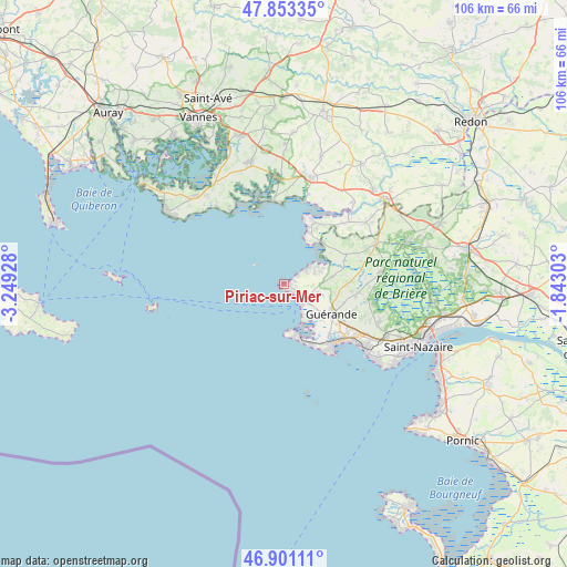
Piriac-sur-Mer GPS coordinates[2]
47° 22' 45.768" North, 2° 32' 46.176" West
| Map corner | latitude | longitude |
|---|---|---|
| Upper-left | 47.85335°, | -3.24928° |
| Center: | 47.37938°, | -2.54616° |
| Lower-right: | 46.90111°, | -1.84303° |
| Map W x H: | 105.9×105.9 km | = 65.8×65.8mi |
| max Lat: | 51.07786° ⇑50.4% North |
| Piriac-sur-Mer: | 47.37938° |
| min Lat: | ⇓49.6% South 41.3874° |
| min Long | Piriac-sur-Mer | max Long |
| -5.08615° | -2.54616° | 9.52242° |
| W 3.7%⇐ | ⇒96.3% E |
Elevation
Elevation of Piriac-sur-Mer is 6 m = 20 ft, and this is 187.7 m = 616 ft below average elevation for this country.
| Max E: |
2333 m = 7654 ft | 99% |
| Avg. | 193.7 m = 635 ft | |
| Piriac-sur-Mer | 6 m = 20 ft | |
Min E: |
-1 m = -3 ft | 1% |
See also: France elevation on elevation.city.
Geographical zone
Piriac-sur-Mer is located in North temperate zone (between Tropic of Cancer and the Arctic Circle). Distance of this North polar circle is 2133.1 km =1325.4 mi to North.| Distance of | km | miles | from Piriac-sur-Mer |
|---|---|---|---|
| North Pole | 4739 | 2944.7 | to North |
| Arctic Circle | 2133.1 | 1325.4 | to North |
| Tropic Cancer | 2662.2 | 1654.2 | to South |
| Equator | 5268.1 | 3273.4 | to South |


Nearby cities:
15 places around Piriac-sur-Mer: (largest is in red/bold)
• Assérac
13 km =8.1 mi,  65°
65°
• Batz-sur-Mer
12.4 km =7.7 mi,  156°
156°
• Billiers
17.4 km =10.8 mi,  14°
14°
• Camoël
16 km =9.9 mi,  45°
45°
• Damgan
15.6 km =9.7 mi,  351°
351°
• Guérande
10.5 km =6.5 mi,  122°
122°
• La Baule-Escoublac
16.8 km =10.4 mi,  125°
125°
• La Turballe
4.7 km =2.9 mi,  141°
141°
• Le Croisic
10 km =6.2 mi,  165°
165°
• Le Pouliguen
15.1 km =9.4 mi, 143°
• Le Tour-du-Parc
17.9 km =11.1 mi,  335°
335°
• Mesquer
6.9 km =4.3 mi, 71°
• Pénestin
12.7 km =7.9 mi,  25°
25°
• Saint-Lyphard
18.2 km =11.3 mi,  83°
83°
• Saint-Molf
9.3 km =5.8 mi, 81°
Sources, notices
• [Note1] Compared only with cities in France existing in our database
• [Src1] Map data: © OpenStreetMap contributors (CC-BY-SA)
• [Src2] Other city data from geonames.org with taken over terms of usage.
• [Src3] Geographical zone / Annual Mean Temperature by Robert A. Rohde @ Wikipedia
